What are you looking for?

Shutterstock_2292093771

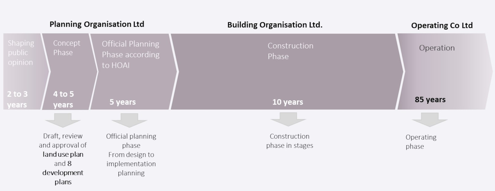
The planning phase is expected to take five years - with a lead time of around four years for the creation of a land use plan and eight comparatively detailed development plans based on a very detailed "concept plan"

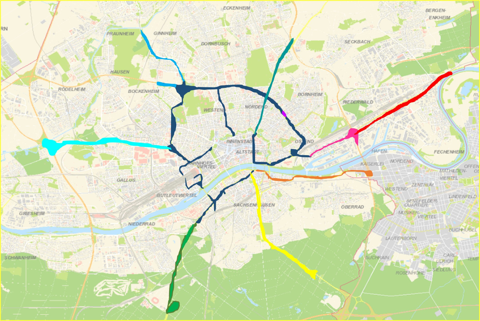
In the four-year lead time before the actual start of planning in accordance with the offical German planning phases (HOAI), an area plan and 8 development plans must be developed: one development plan for the ring road and one development plan for each of the seven bridge arms.

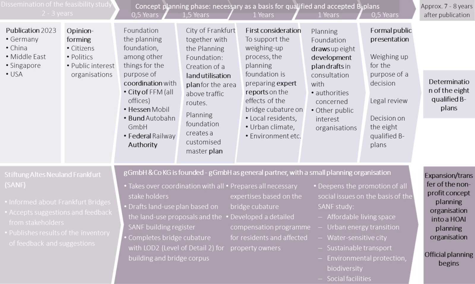
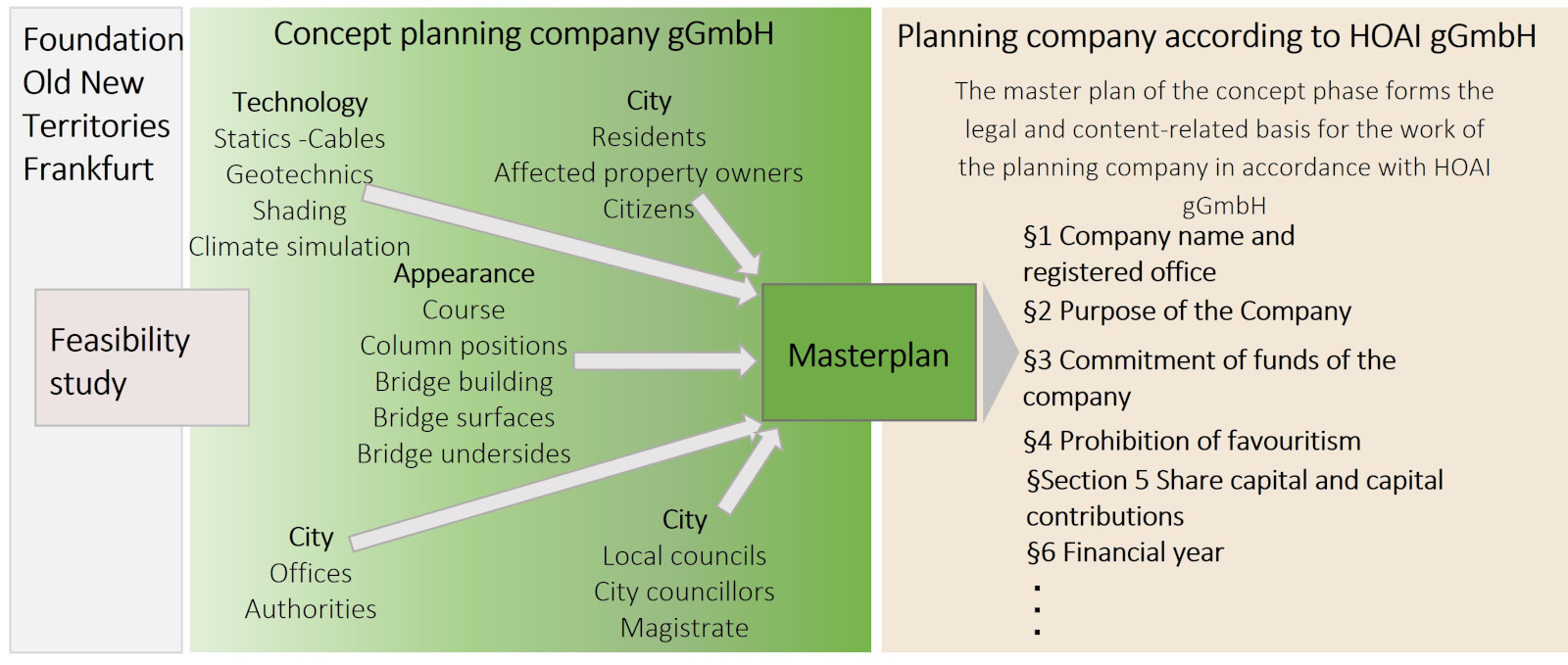
This four-year "concept planning phase" should be carried out by a non-profit concept planning company (Concept Company Ltd) which, in preparation for the preparation of the development plans, will continue the detailed planning of the Frankfurt Bridges that was started by the Stiftung Altes Neuland Frankfurt as part of the feasibility study. The non-profit nature of the organisation ensures that the entire concept of the Frankfurt Bridges is transparently geared towards the common good of all citizens, both now and for future generations.  Subsequently and based on this, the official 5-year planning according to HOAI will take place.

Both in the concept planning phase and in the classic planning phase according to the offical German planning phases (HOAI), close co-operation with the relevant offices at city and state level is absolutely essential, in the course of which extensive expert opinions and studies are prepared for all planning areas in order to make the subsequent construction phase as lean and effective as possible.
 

With good planning and execution, you can walk on the Frankfurt Bridges around 25 years after publication

Stiftung Altes Neuland Frankfurt GNU

Before the actual planning phase begins, a land-use plan must be drawn up for the previously non-existent areas above roads as well as development plans for the previously non-existent overbuilding of road space.

This takes place as part of the four to five-year "concept planning phase", during which a detailed masterplan is drawn up that makes it possible to make the land use plan and the development plans much more meaningful and more tangible for citizens than is usually the case. 
 

The land use plan and the eight development plans must not only be designed, but also examined and harmonised in numerous aspects by experts

Stiftung Altes Neuland Frankfurt GNU

A proposal for the land utilisation plan has already been created by the Altes Neuland Frankfurt foundation

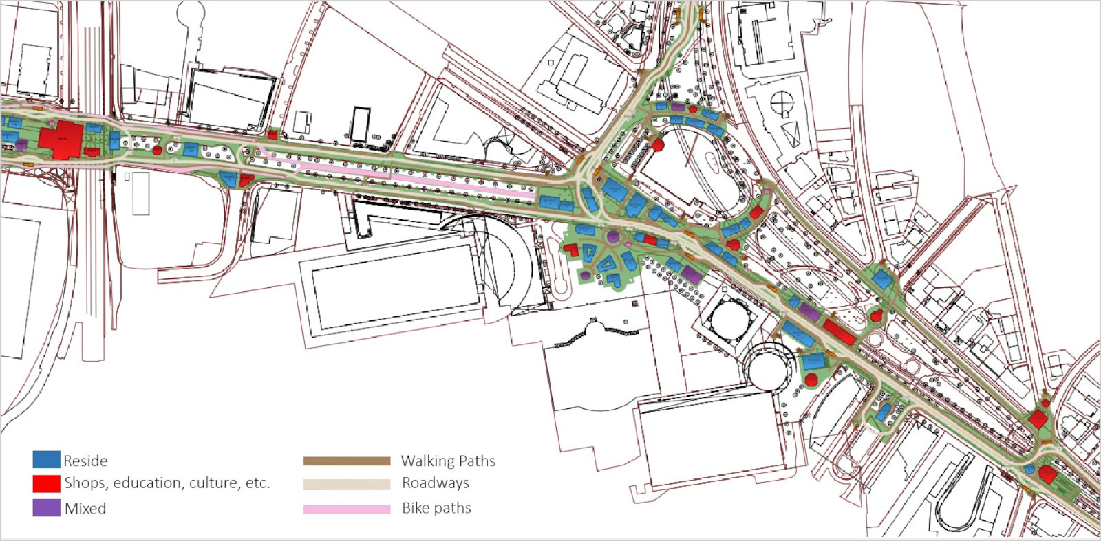
The proposal for the utilisation of all areas was planned into the city maps of the City of Frankfurt: Areas for traffic have been defined as well as green spaces, construction windows for buildings and the type of use of the buildings. 
 

Stiftung Altes Neuland Frankfurt / GNU

The feasibility study by the Stiftung Altes Neuland Frankfurt also provides the basis for the development plans that have to be drawn up for the Frankfurt Bridges

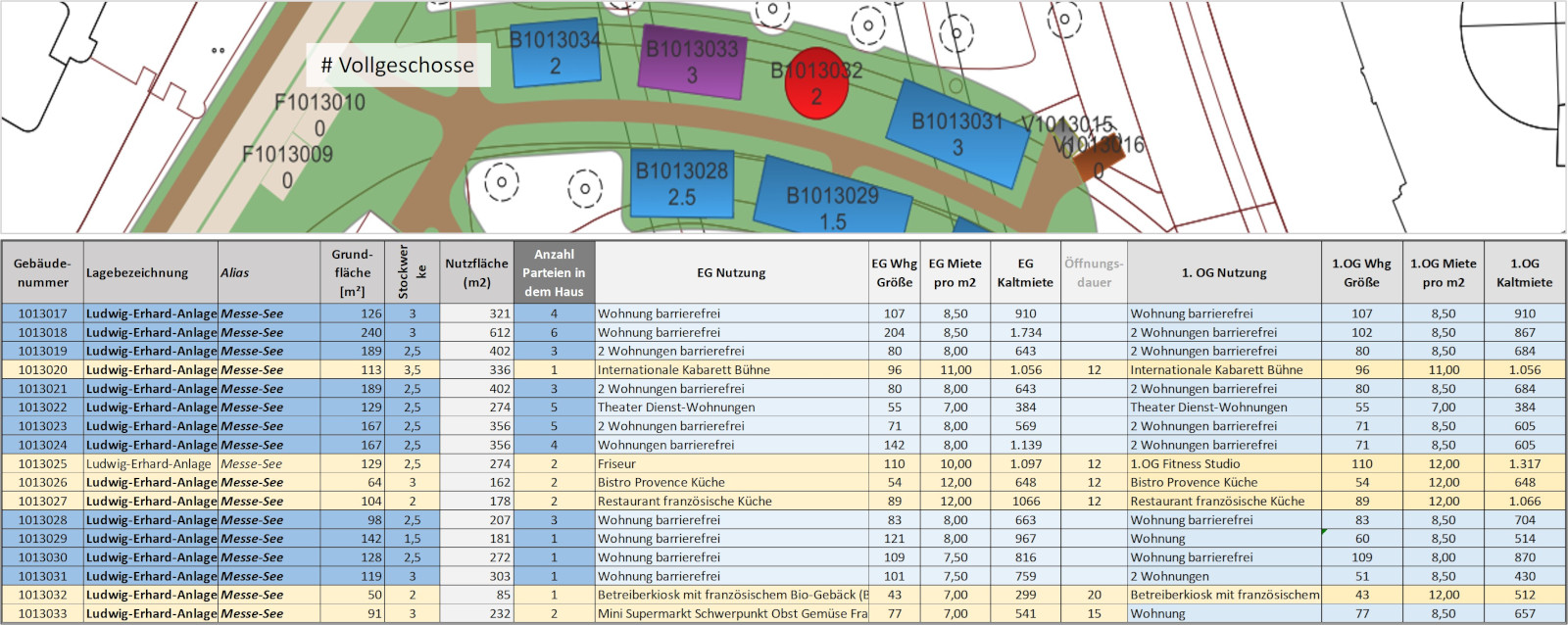
The most important key data for the development plans can be taken from the planning of the Stiftung Altes Neuland Frankfurt: Not only was the land use on the bridges defined on the basis of urban base maps, but a bridge building cadastre was also created. This makes a proposal for

  • the superstructureable property areas
  • the type of building use (which already provides the basis for the land use plan), including potential tenant groups
  • the degree of building utilisation: the floor area ratio (GRZ), the floor area ratio (GFZ) and the number of full storeys are entered.
     
Stiftung Altes Neuland Frankfurt / GNU

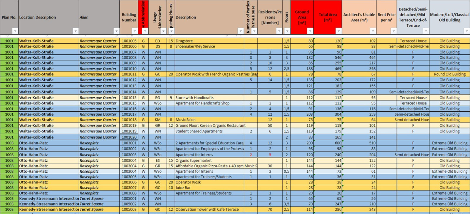
The building register from the feasibility study will be revised and supplemented to form the basis for the detailed development plan

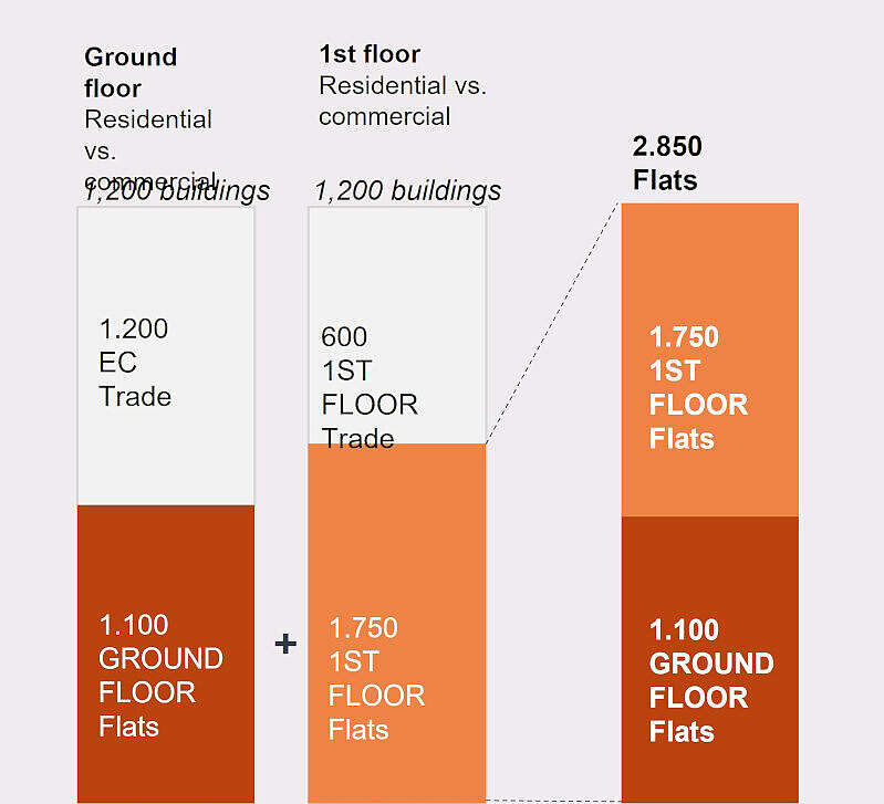
Only with a transparent building register that is designed for the common good can citizens approve the development plans: The cadastre not only clarifies the scope and design of affordable housing, but also gives people in the neighbourhoods along the Frankfurt Bridges an impression of what is to be offered in their immediate vicinity: Kindergartens, exotic bistros, fitness and sports facilities, music venues, medical care and much more. c
 

Stiftung Altes Neuland Frankfurt GNU

The land use in the feasibility study must be coordinated with the urban requirements planning of the urban planning office before the development plans are adopted and optimised if necessary

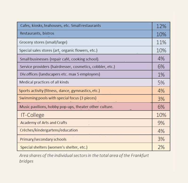
Culinary and education take up the largest "non-residential space" on Frankfurt‘s Bridges

Newly built neighbourhoods often suffer from a lack of "life": there are usually two reasons for the lack of non-residential accommodation:

  1. Building land is designated primarily because there is a high demand for new living space
     
  2. Catering, sports, cultural and educational facilities are often not worthwhile in new development areas due to the low population density and poor accessibility.

Both reasons are invalidated in the Frankfurt bridge concept: living space for more than 30,000 people is being created on the bridges, and all areas of the Frankfurt Bridges are either close to the city centre or can be reached by bridge transport within a very short time.
 

Stiftung Altes Neuland Frankfurt GNU

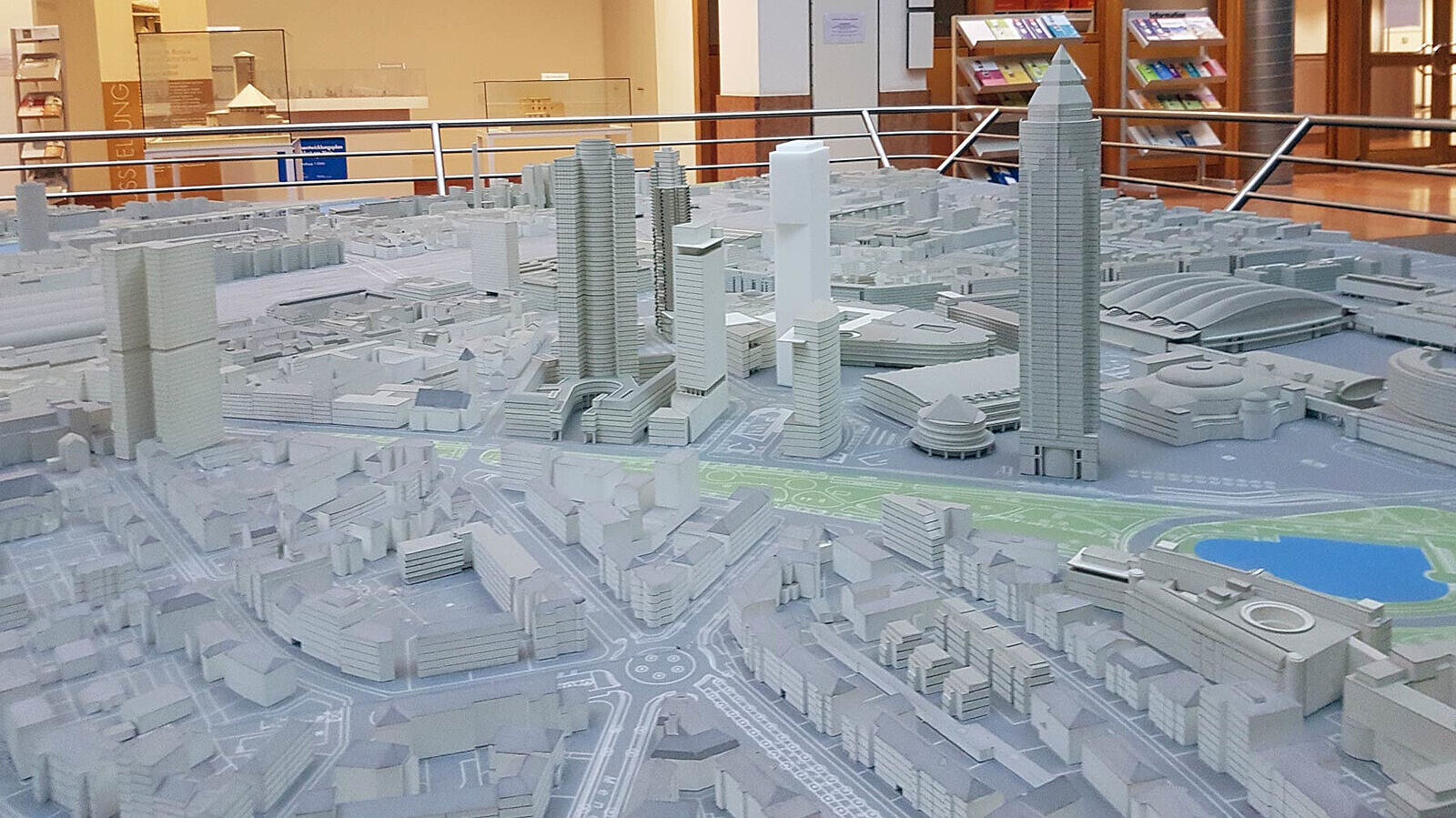
Qualified development plans of this size are displayed next to the city model in the atrium of the Frankfurt City Planning Office to give all citizens the opportunity to view them at their leisure

Ordinary development plans generally do not have anywhere near the level of detail proposed by the Stiftung Altes Neuland Frankfurt for the masterplan in the run-up to the establishment of the 8 development plans for the Frankfurt Bridges. 
 

Stadtplanungsamt FFM

In the concept phase, a "master plan" of the entire bridge surface must already be drawn up, which gives all those involved a precise picture of the design of the "Frankfurt Bridges" so that coordination with authorities, considerations, expert opinions,

During the preliminary phase ("concept planning") prior to the actual start of planning, the bridge corpus is already planned together with the building cubatures. The following details are added in this design phase of the concept planning:

  • The architectural style is defined for all neighbourhoods
  • All buildings are assigned a final use
  • Revit drawings are produced for all buildings on this basis
  • The landscape architectural design of the entire bridge is being worked out
  • This also includes a precise description and calculation of the lighting
  • as well as the planning of all accesses to the bridges: lifts, stairs, escape stairs
  • The types of use are defined for public green spaces.
  • Furthermore, the planting of all green spaces - both public and private - will be defined as part of the landscape architectural design.

This masterplan is based on the templates provided by the Stiftung Altes Neuland Frankfurt, which has undertaken such a detailed design for sections of the Frankfurt Bridges as part of the feasibility study. The concept phase for the creation of the masterplan will take around four to five years in total. 
 

Stiftung Altes Neuland Frankfurt GNU

The Concept Company Ltd. must carry out a great deal of preliminary work during the 4 to 5 years of planning so that the eight development plans have a good chance of being adopted in the medium term

The Concept Company Ltd. takes over the coordination with all stake holders
 

  • At city level: City councillors, local councils, all departments, the city planning office, Netzdienste Rhein Main (NRM), Mainova, Stadtentwässerung Frankfurt (SEF), Frankfurter Entsorgungswerke (FES), Verkehrsgesellschaft Frankfurt (VGF), Frankfurter Behinderten-Arbeitsgemeinschaft (FBAG), Grünflächenamt, Umweltamt Bauamt, Branddirektion, Wasserstraßen- und Schiffahrtsamt and others.
     
  • At state level: Hessian state parliament, Hessian ministries, Hessian state offices (in particular HLNUG and Hessen Mobil)
     
  • Citizens' initiatives, associations, organisations (especially the Chamber of Crafts, Chamber of Industry and Commerce and interest groups such as FBAG)
     
  • Higher education institutions and research institutes in Frankfurt and Hesse ( = stakeholder for the Frankfurt Bridges as a showcase for innovation and Frankfurt as an innovation centre in Europe)
     

It deepens the promotion of all social issues on the basis of the study by the Altes Neuland Frankfurt Foundation

  • Affordable housing ̶ Sustainable transport ̶ Promotion of art and culture
     
  • Urban energy transition ̶ Environmental protection, biodiversity ̶ Inclusion
     
  • Water-sensitive city ̶ Social facilities Etc.
     

It drafts the land-use plan on the basis of the land-use proposals in the bridge masterplan of the Altes Neuland Frankfurt foundation
 

It completes the bridge cubature: both for the bridge body and for the bridge buildings. At this early "pre-planning stage", the bridge corpus and the bridge buildings are shown in simple 3D Revit models with LOD2 (Level of Detail 2). This all flows together in a "masterplan" (see below).
 

On the basis of the bridge cubature, the Concept Company Ltd. has all the necessary expert reports prepared that are relevant for the consideration process, in particular
Simulations of the impact that Frankfurt's bridges could have on the city's climate: As part of the feasibility study, eight climatically critical points along the bridge route were identified. These results must be checked and the simulation carried out for all potentially critical areas.
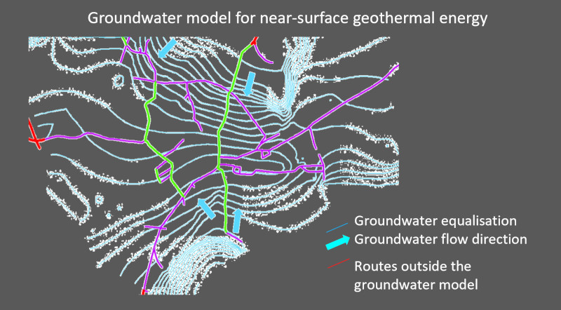
If necessary, in coordination with the Hessian State Office for Environment and Geology: Expertise on the effects of infiltration systems and geothermal systems on the groundwater in Frankfurt
Shadow analyses for all sections of the Frankfurt Bridges where there are residential buildings
Geological reports to underpin the statics 
Geological expertise on the detailing of the near-surface geothermal system of the Frankfurt Bridges
Energy expertise on supply options and grid requirements when creating new supply structures
Among others.
 

On the basis of the shading reports, the planning company is drawing up a detailed compensation programme for residents and affected property owners 
 

Due to the clear focus of the Frankfurt Bridges infrastructure project on environmental protection and nature conservation as well as on numerous important social and cultural issues, there is a good chance that the development plans for the Frankfurt Bridges will meet with broad approval and can be adopted relatively quickly


In order to minimise subsequent plan changes due to dissatisfied citizens or authorities, the master plan from the concept planning phase should provide a clear picture of how the bridge, including its superstructure and surface design, will look in each section
 

The masterplan serves as the final coordination basis for compensating the residents, especially as the residents are the third important stakeholder group alongside the investors and the City of Frankfurt: The masterplan finalises the shape of the buildings on the bridges and the planned planting, so that shading can be recorded even more precisely and, if necessary, modified in the masterplan, which has an impact on the compensation claims.

A detailed masterplan of the buildings and green spaces is also needed for residents who would prefer to receive the right to alternative living space on the bridges or the lifelong use of a bridge allotment instead of monetary compensation in the form of rent payments or bank charges. Only once the masterplan is in place will these residents be able to choose what they want on the bridges.

Furthermore, the master plan can be used to finalise coordination with the relevant authorities of the City of Frankfurt before the final resolution is passed by the gGmbH and the master plan is included in the statutes: Mainova, Frankfurter Entsorgungswerke, Stadtentwässerung Frankfurt, Rhein-Main-Netzdienste or even the VGF or the fire department etc. can only give their final approval to the design of the Frankfurt Bridges if they have a detailed proposal. 
 

The most important building block for the realisation of the Frankfurt Bridges is acceptance: To this end, the concept planning must make the bridges tangible and attractive for local residents in advance of the actual "planning phase according to HOAI"

The most important prerequisite for the realisation of the Frankfurt Bridges is a thorough resident analysis, in particular shadow analyses for each individual building along the route. Even before the start of the actual planning or before the adoption of a development plan, a compensation plan for the building owners and residents potentially affected by the bridge construction must be developed as part of an approximately four to five-year "concept planning", which is so attractive that building owners and residents along the bridge route are the biggest winners and thus the biggest supporters of the construction project and do not become disadvantaged opponents.   

Another prerequisite in the run-up to the actual planning phase are concepts that ensure that the space under all bridge sections is bright and appealing: lighting concepts, light holes in the bridge body, pleasant music that plays on the lonelier bridge sections, which must also be monitored by cameras, artistic design, etc. All of this must be detailed in the concept planning in such a way that there is no separation between "above" and "below" the bridges.- All of this must be detailed in the concept planning in such a way that there is no separation between "above" and "below" the bridges, but that the undersides of the bridges or spaces under the bridges are bright, green, airy, artistically impressive and pleasant for all people who approach them. In this context, a connection between above and below must also be created, e.g. by means of purely seated staircases on the bridges, opening bridge balconies with glass balustrades, light holes with waterfalls, etc.  

Furthermore, the "Frankfurt Bridges" infrastructure project can only be realised in cooperation with the City of Frankfurt, even if all investors come from the private sector: This is because the "city of the future" can only be created if all the offices and authorities involved (planning office, building authority, environmental office, green space office, city surveyor etc etc) and also utilities (Mainova, VGF, NRM, SEF etc etc) are at the table during the planning phase. For the city, this means that it will have to recruit specialised staff specifically for the construction of Frankfurt's bridges, as the service providers in all of the city's offices and utility companies are already massively overworked. Only if these service providers are approved for positions that relieve their own workload or that they can deploy for project work on the bridges can the dovetailing with the bridge project succeed - even without it being a classic public-private partnership construction.  
The result of the concept planning phase, the "master plan", not only forms the content basis for the first two service phases of the HOAI,

 but also flows into the non-profit purpose in the articles of association of the planning company in accordance with HOAI gGmbH 

The master plan becomes part of the planning to be realised - this avoids change costs in the course of all later service phases.   

And in the run-up to the actual start of the entire project, legally valid commitments have already been obtained from authorities, residents, affected property owners and politicians on the basis of the masterplan, which will significantly increase the efficiency of the construction project.  

Stiftung Altes Neuland Frankfurt GNU

Why is the concept phase with detailing, precise design of the bridges, bridge surfaces, undersides and bridge buildings so important? Why should a detailed masterplan be drawn up before the HOAI planning phases, which include similar steps?

  1. The most important reason is that all citizens - residents and other affected parties - already have a precise idea of what the construction project will look like when the master plans are presented. Only if all citizens know exactly what is in store for them through the masterplan (incl. expert opinion, compensation plan, etc.) do the development plans have a good chance of being accepted.  In order to ensure this transparency and to guarantee that the design is primarily focussed on the common good of current and future generations, the Altes Neuland Frankfurt Foundation proposes that the concept planning will be carried out by a non-profit "Concept Company Ltd.".   
  2. All involved offices and units of the City of Frankfurt and the State of Hesse can only provide valid commitments and confirmations if the masterplan already has the necessary level of detail. This significantly streamlines the subsequent planning steps in accordance with HOAI and ensures that the subsequent construction phase can also be carried out with maximum efficiency and thus extremely cost-effectively.   
  3. This in turn ensures that the "Frankfurt Bridges" construction project does not lead to a cost explosion and/or extreme delays, as is the case with many other major infrastructure projects in Germany.   The greatest costs in infrastructure projects arise from changes during construction. These can have several reasons 
  • Technical necessities make changes necessary (e.g. geological conditions): This can be minimised with a detailed master plan, as this already includes a rough TGA plan. 
  • Authorisations from state control authorities may not be granted for certain measures: This risk can also be minimised by detailed planning in advance together with all relevant bodies (see above) 
  • Change in the political landscape and thus possible refusal of authorisations: This must be avoided by ensuring that the masterplan for Frankfurt's bridges sets out the benefits for ALL citizens in detail and, like the feasibility study by the Stiftung Altes Neuland Frankfurt, remains completely apolitical and benefits all population groups represented by the various political parties.  

Although Frankfurt‘s Bridges run for the most part through sparsely populated sections, there are stretches of densely populated residential areas along the bridges, especially towards the city centre

8 B-plans: one for the ring road and seven for the respective arms of the Frankfurt Bridges 

Stiftung Altes Neuland Frankfurt GNU

Only with a detailed master plan, optimised to the needs of the citizens, is there a chance that the B plans will not only be accepted, but also welcomed

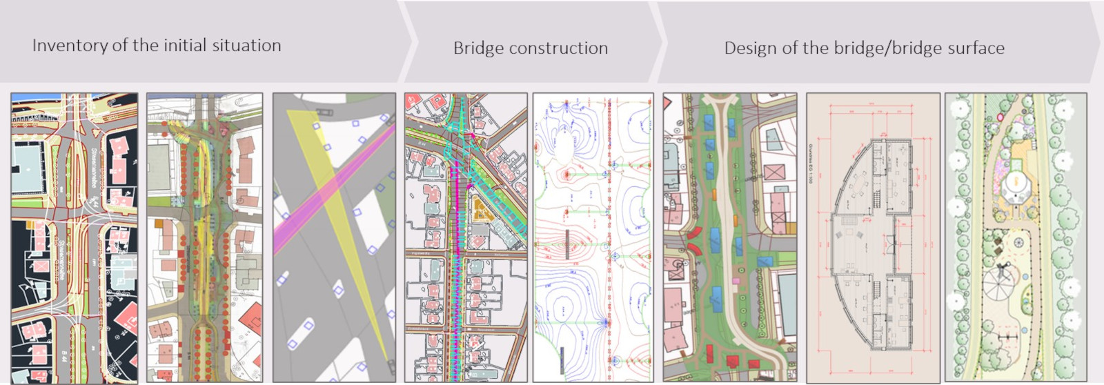
In the concept planning phase, a detailed masterplan is drawn up from the plan contents of the feasibility study by the Altes Neuland Frankfurt Foundation

In the feasibility study, the most important steps of concept planning were run through for some neighbourhoods as examples:  

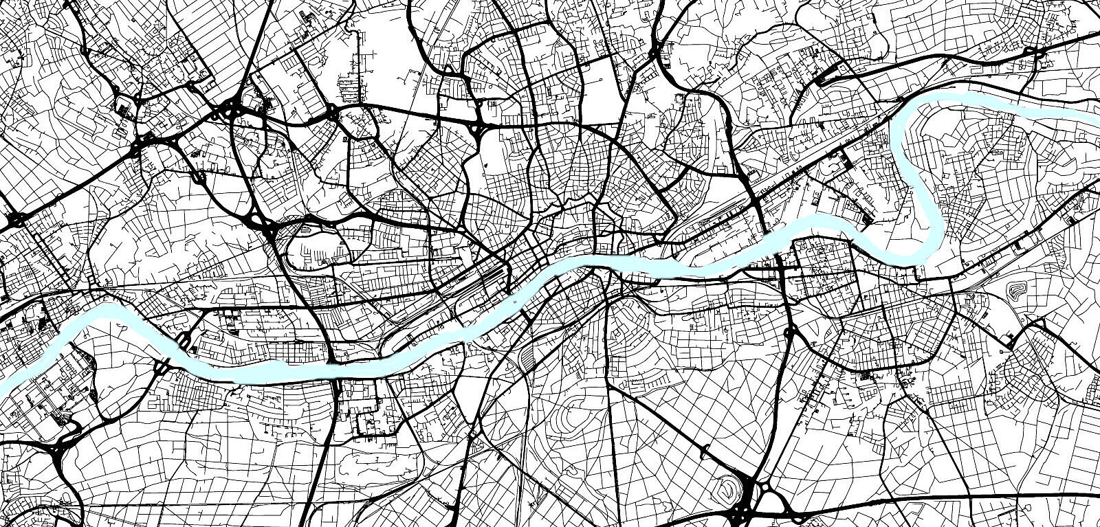
  1. Definition of the georeferencing framework parameters as the planning basis for all elements on the city base map 
  2. Route and column positioning, taking into account trees, driveways, escape routes, sight lines, cables, etc. Including the medium and long-term traffic planning of the city of Frankfurt - as far as known 
  3. All traffic conditions on the roads must also be taken into account when positioning the bridge pillars  
  4. Statics and load maps for each section 
  5. Analysis of the intersections of the column piles with supply lines in the ground 
  6. Revit design of the bridge, incl. accesses (stairs, lifts), footpaths, driveways, car parks and stations 
  7. Piping plan for all bridge cables across the entire bridge section 
  8. Buildings per neighbourhood section in Revit (incl. floor plans) and all supply centres on the bridges 
  9. Shadowing analysis and resident analysis for the entire course as well as rough analysis of the compensation plan 
  10. Landscape architectural design of the sections in Vectorworks (incl. lighting, park benches, Renomat roundels etc.) 
  11. Exemplary visualisations per neighbourhood to give citizens an idea of each neighbourhood 
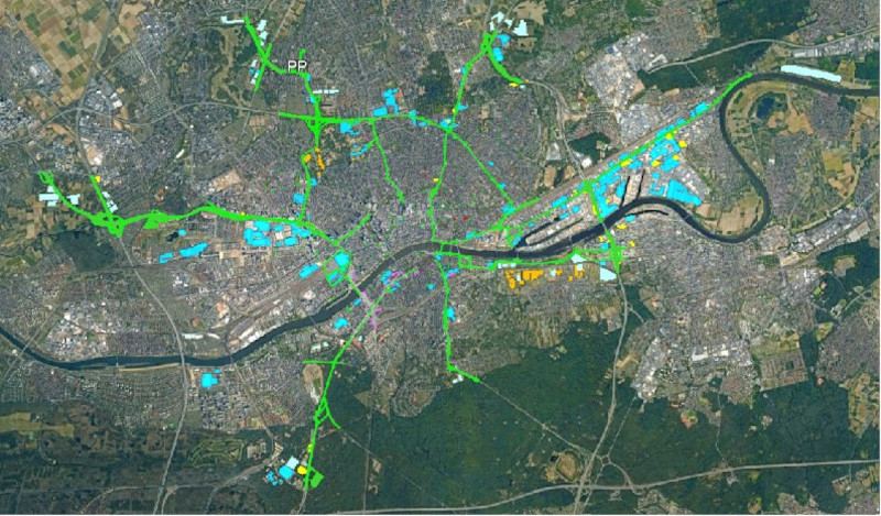
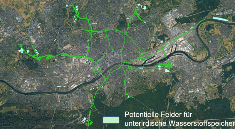
  12. Recording of all integrable structures along the bridges: Roofs for solar panels and rainwater harvesting, waste heat harvesting from data centres and industry, fields for underground hydrogen storage, etc. 
  13. Planning of all underground structures along the bridge: Pipes, cisterns, energy storage tanks, probe fields 
  14. Planning the fire protection structures along the bridges in conjunction with the existing Frankfurt fire protection system 
  15. Planning the dovetailing of bridge traffic and urban transport 

The planning steps for the master plan do not all follow a strict sequence, but are largely iterative

For the sake of simplicity, they are described here as a sequence, but in reality they usually have to be carried out in parallel or iteratively: For example, the load map, the statics and thus the number and positioning of the columns for a section can only be determined once the buildings for the section have already been defined. Conversely, buildings can only be positioned once a rough basic plan of the bridge surface and the course of the bridge is available.   

The columns on which the statics rest must also be placed in advance, taking into account the trees along the road, the pipes in the ground and the width of the cycle path or pavement. As soon as the course of the bridge and the buildings on it have been planned, columns may have to be added or moved again in order to bear the load.  This iterative approach may also be necessary in the event of changes to the traffic routing under the bridges. 

Stiftung Altes Neuland Frankfurt GNU

In step 1, the coordinate system in which all georeferencing of the planning is to take place must be determined in order to be able to create the planning unambiguously on the basis of the Frankfurt city maps

Stiftung Altes Neuland Frankfurt GNU

Step 2: Positioning the columns and derived bridge surface

During column positioning, the bridge area potential is explored taking into account

(above ground) 

  • Proximity to the buildings on the right and left and type of development (commercial or residential) 
  • Entrances and exits that must remain clear 
  • Bicycle and pedestrian paths that must not be impaired

(underground) 

  • Trees from which a minimum distance (to be defined according to the age of the tree) must always be maintained to protect the root system 
  • Pipes that lie in the ground and must either be enclosed or relocated if the "pile" of a column (see below) comes to rest on them. 
Stiftung Altes Neuland Frankfurt GNU

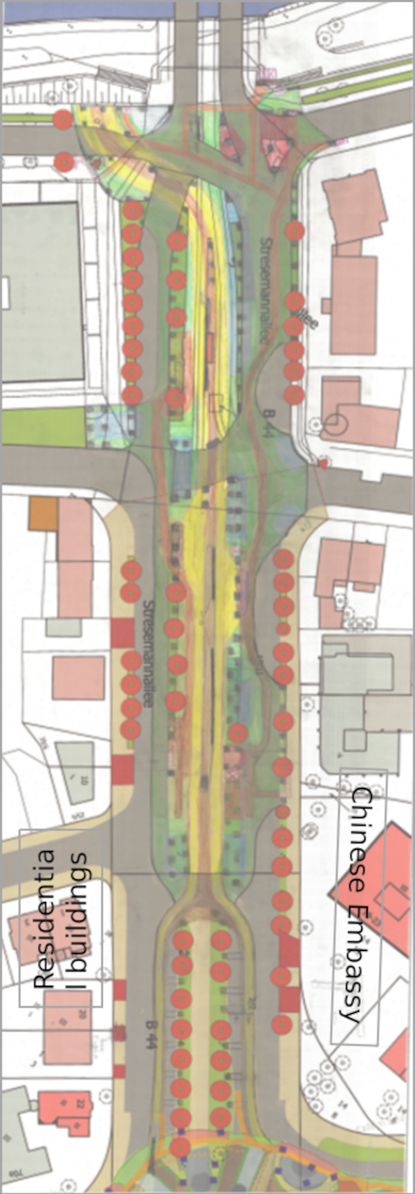
For step 2, there are hand drawings on city base maps for the 50 km long route of the Frankfurt Bridges

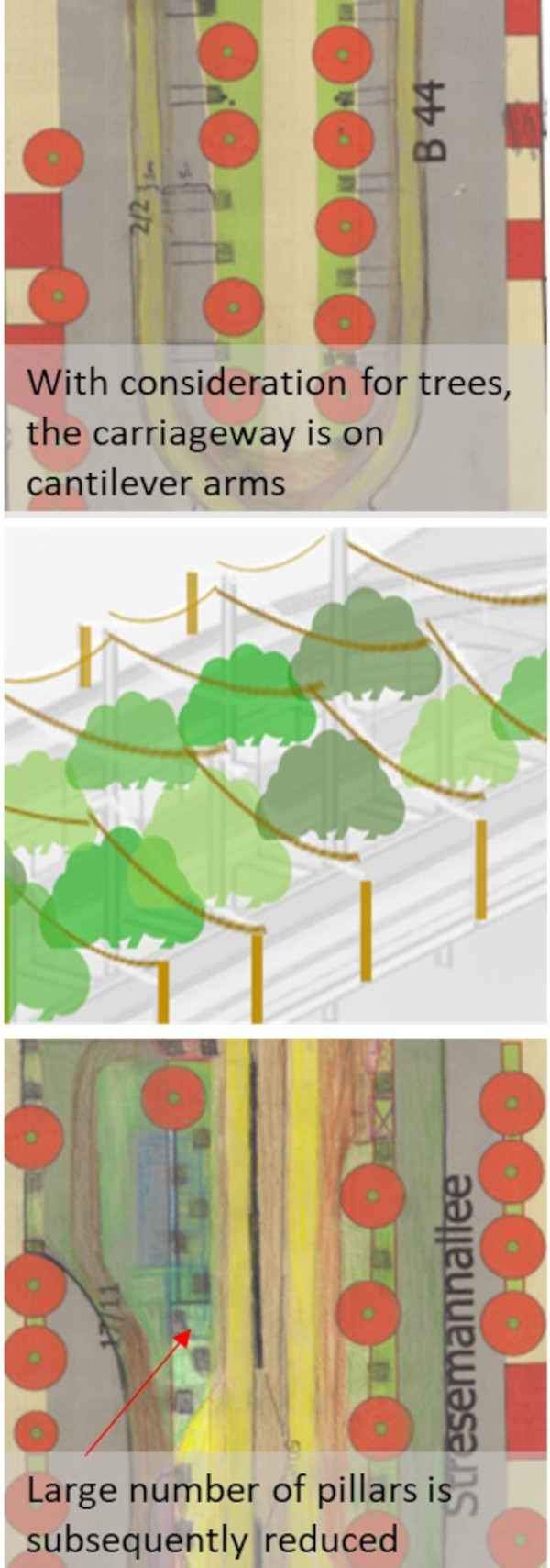
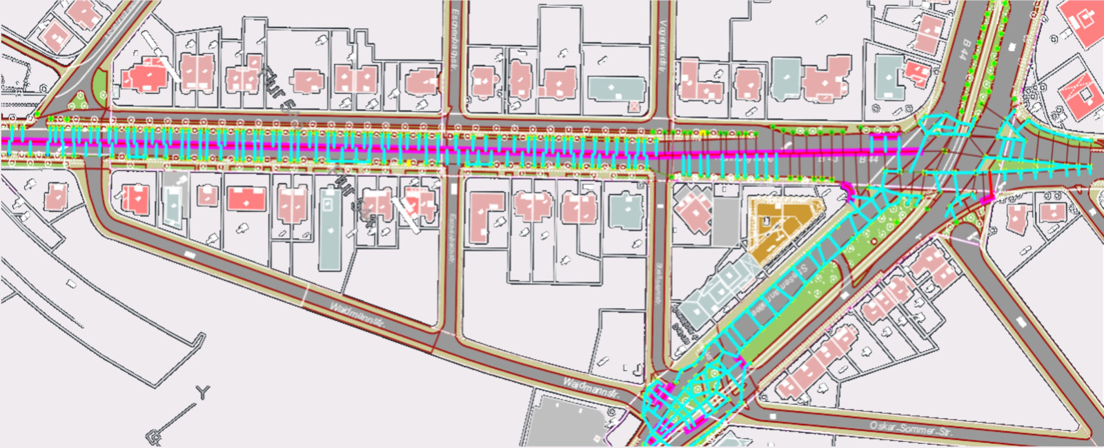
Trees are already marked on the city base maps, which are provided with a (here red) protection radius in the course of planning. The pillars (here square pencil symbols) are positioned at the appropriate distance.  

The example of "Little Italy" above Stresemann-Allee shows how the road and pedestrian paths were not placed on pillars in front of the Chinese Embassy or in front of the residential buildings on the opposite side of the street, but between the trees.   

As the plane trees are too dense at this point and have comparatively large crowns, the carriageway was laid on cantilevers over the road and supported above by a tensioning structure.   

Where there are no trees, a large number of columns are placed, from which those not required can be removed in the course of the preliminary structural analysis.   

Stiftung Altes Neuland Frankfurt GNU

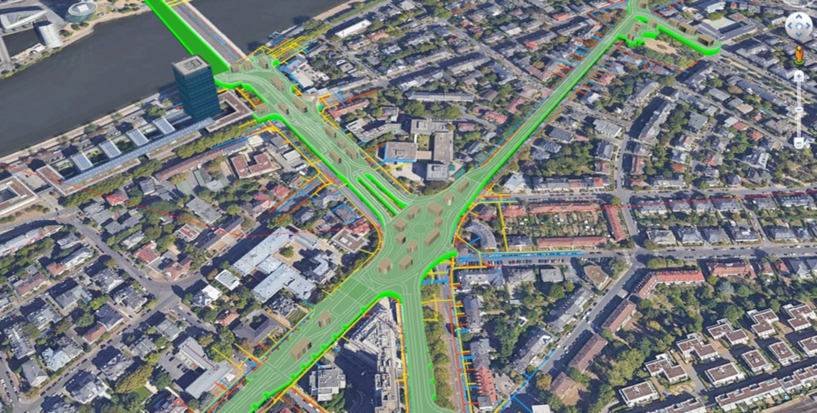
Step 2: Positioning of the pillars was largely carried out in the feasibility study of the Atles Neuland Frankfurt Foundation, taking into account the cables in the ground

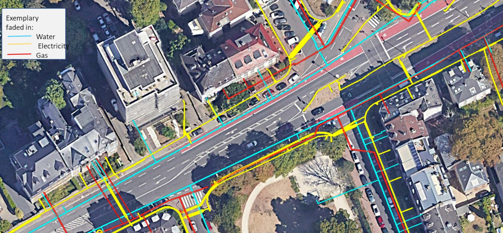
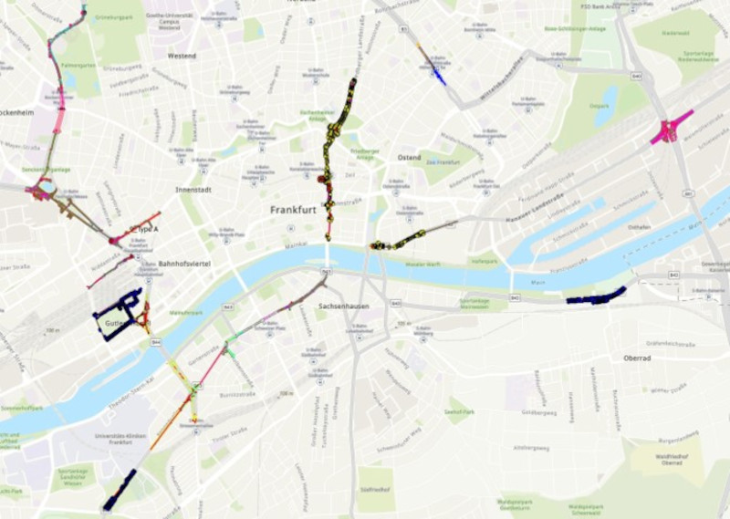
Particularly in the ring around the city centre, the most important lines were georeferenced as part of the feasibility study. Smaller sections of the Frankfurt Bridges have even been vectorised in order to rule out collisions with columns or to reduce them to such an extent that any remaining overlaps can be mitigated by enclosing the cables or relocating them. 

Google Earth

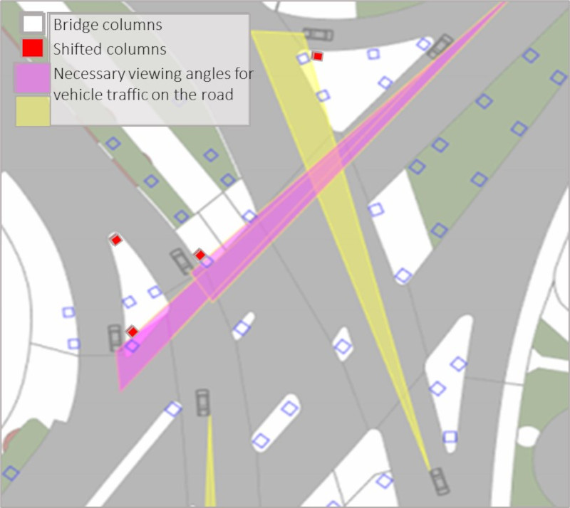
Step 3: All traffic modalities on the roads as well as the city's plans for them must be taken into account when placing the bridge pillars

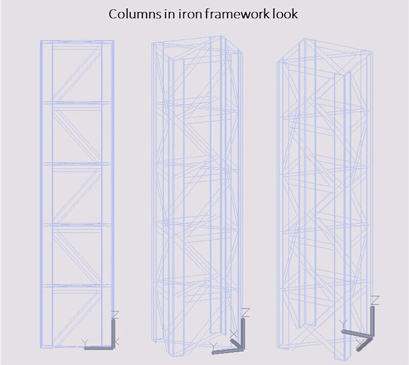
All bridge planning columns can be moved up to one metre in all directions. If the visual angle analysis reveals that a column is obstructive to traffic, it can either be moved or replaced by a column made of iron trusses: This is an alternative solution, especially if the column needs to be moved by more than one metre.  

Stiftung Altes Neuland Frankfurt GNU

Step 4: Which columns are required and what load can be placed on the bridge surface?

The preliminary structural analysis checks which of the pillars are required   

  • To carry the minimum: two lanes (one on the right and one on the left, including the edge of the bridge) and a footpath in the centre  
  • To maximise urban life on the section: Buildings, special planting areas (therapy gardens, urban gardening, shady small trees, etc.) or simply meadows (dog meadows, yoga meadows, etc.).  
  • To find the optimum balance between as much urban life as possible versus static expenditure (which always goes hand in hand with additional consumption of grey energy and is therefore a limiting factor) on the basis of load maps in an iterative process together with the neighbourhood planners.  

As part of the feasibility study by the Stiftung Altes Neuland Frankfurt, a preliminary structural analysis has already been carried out for the ring road and critical sections of the seven bridge arms (e.g. routing of the Frankfurt Bridges over railway or motorway bridges).   

Furthermore, preliminary structural analyses were carried out for the various designs of the Frankfurt Bridges (solid columns, translucent truss columns, bridge with glass body, steel truss bridges).   

These preliminary statics of the feasibility study must be supplemented as part of the concept planning for the entire bridge route. In addition, expert inspections should be carried out at geologically critical points.  

The preliminary statics in step 4 show where there are columns and where there are beams

The course of the beams is important later in order to sound out the possibilities for light holes in the bridge body (after setting the building construction windows): These can only be embedded in the bridge floor at a minimum distance of 50cm from the beams. 

Stiftung Altes Neuland Frankfurt GNU

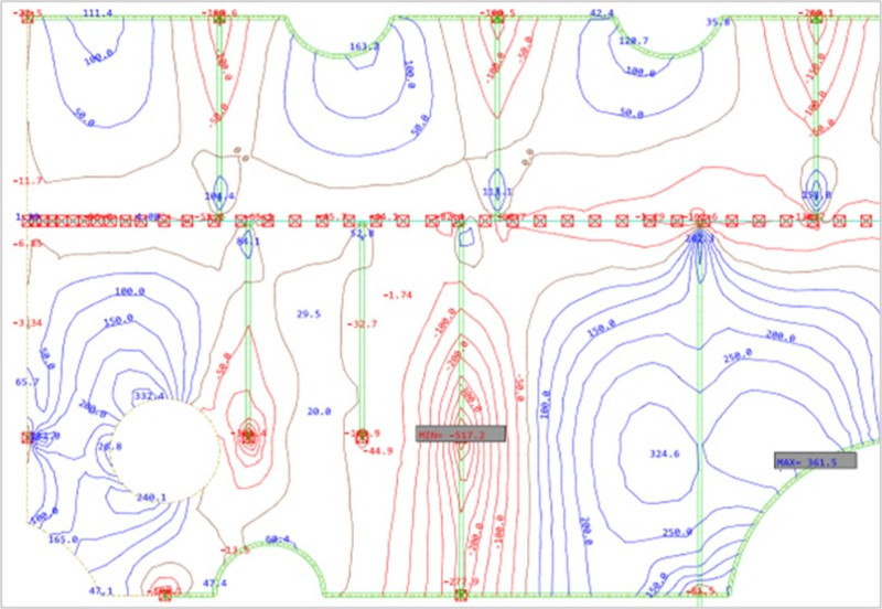
The preliminary structural analysis in step 4 provides the basis for building planning with bending moments and load maps

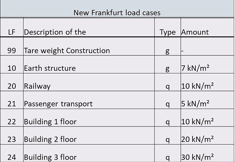
The load map shows at which point how many tonnes of load can be placed on the bridge surface: Accordingly, it is planned where buildings can and cannot be placed and how many storeys these buildings can have. The map with the bending moments shows even more precisely where heavy loads can best be positioned.  

Stiftung Altes Neuland Frankfurt GNU

The preliminary structural analysis in step 4 was created for bridge sections with different requirements

Some of the Frankfurt Bridges are made of steel trusses, but most of them have solid columns; in some places, the bridges have to cross over S-Bahn bridges or other motorway bridges - all these structures are fundamentally different, so separate structural systems were developed for them. It was not possible to create a preliminary structural analysis for the entire bridge route as part of the feasibility study. 

Stiftung Altes Neuland Frankfurt GNU

Step 5 involved analysing the overlaps of the column piles with supply lines in the ground: Thanks to the statics developed as part of the feasibility study, there are only minor overlaps

As part of the feasibility study by the Stiftung Altes Neuland Frankfurt, the overlaps of column piles and supply lines in the ground were examined on a random basis, particularly in the ring of Frankfurt Bridges.   

The analyses show that in inner-city areas with a high line density, over 90 percent of the column piles can be placed without overlapping. The prerequisite for this good result is the structural system developed by the structural engineers at the Stiftung Altes Neuland Frankfurt: This allows bridge pillars to be moved up to one metre in all directions so that the cables can be "avoided", unless other limiting factors come together unfavourably and make it necessary to position a pillar in exactly one place so as not to interfere with driveways, trees, cycle paths, etc.   

If a column cannot be moved due to these factors, it is still possible to relocate pipes as part of the construction project or (e.g. in the case of gas pipes) to enclose them accordingly.  

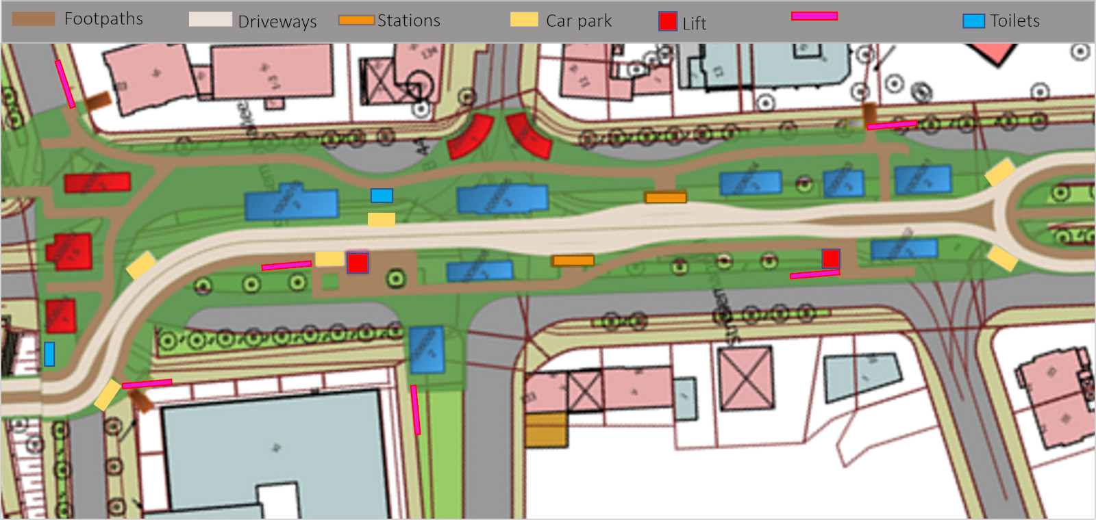
In step 6: Revit design of the bridge, incl. accesses (stairs, lifts), footpaths, driveways, car parks and stations

In addition to the bridge buildings, the entire infrastructure must also be planned for each section. In particular, the stairs and lifts must be designed and positioned in such a way that they do not interfere with the pedestrian and cycle paths.  
Stiftung Altes Neuland Frankfurt GNU

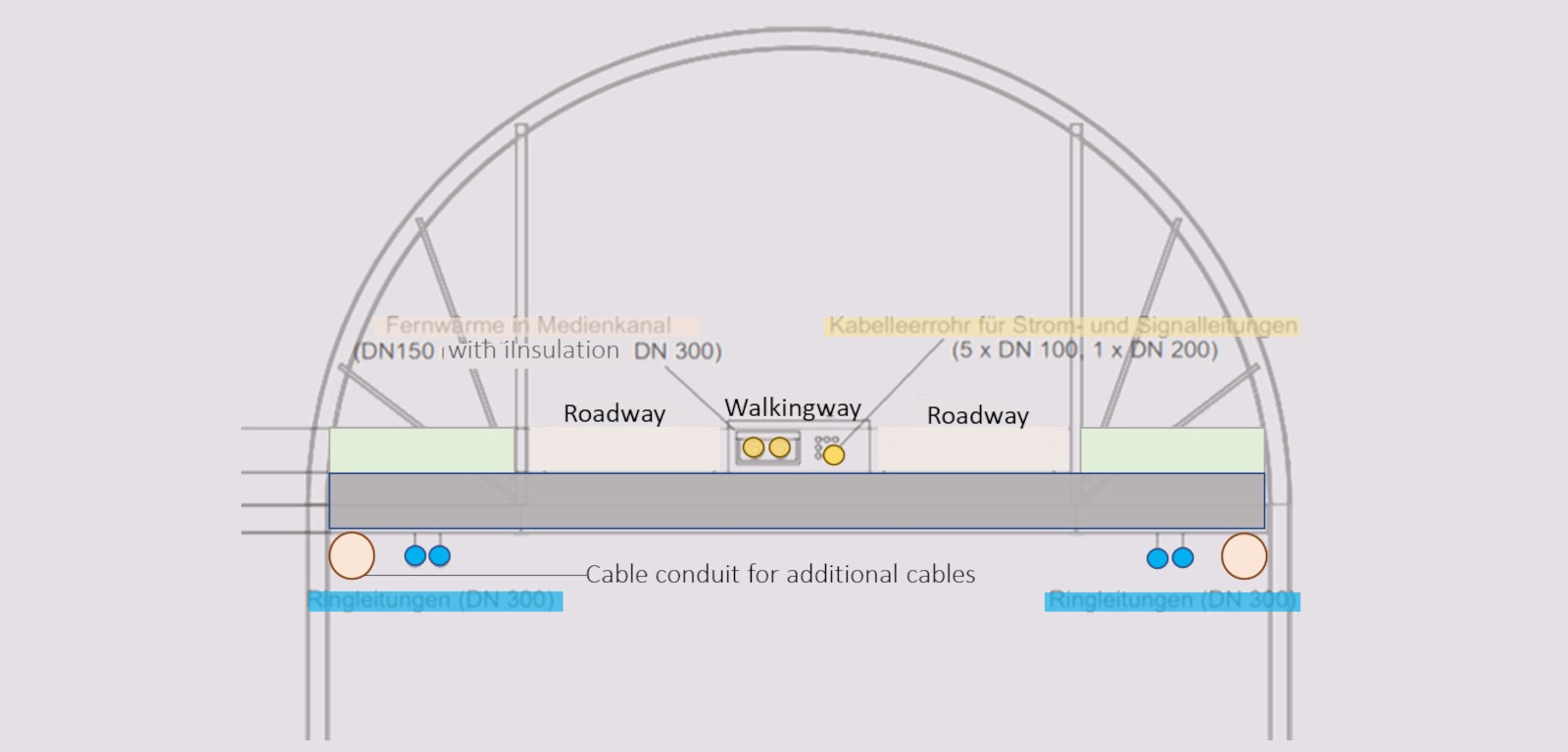
In step 7, the cable plan for all bridge cables is planned across the entire bridge section

The positioning of the cables requires special planning: a large number of cables are installed both in the bridge body and under the bridge. 

Stiftung Altes Neuland Frankfurt GNU

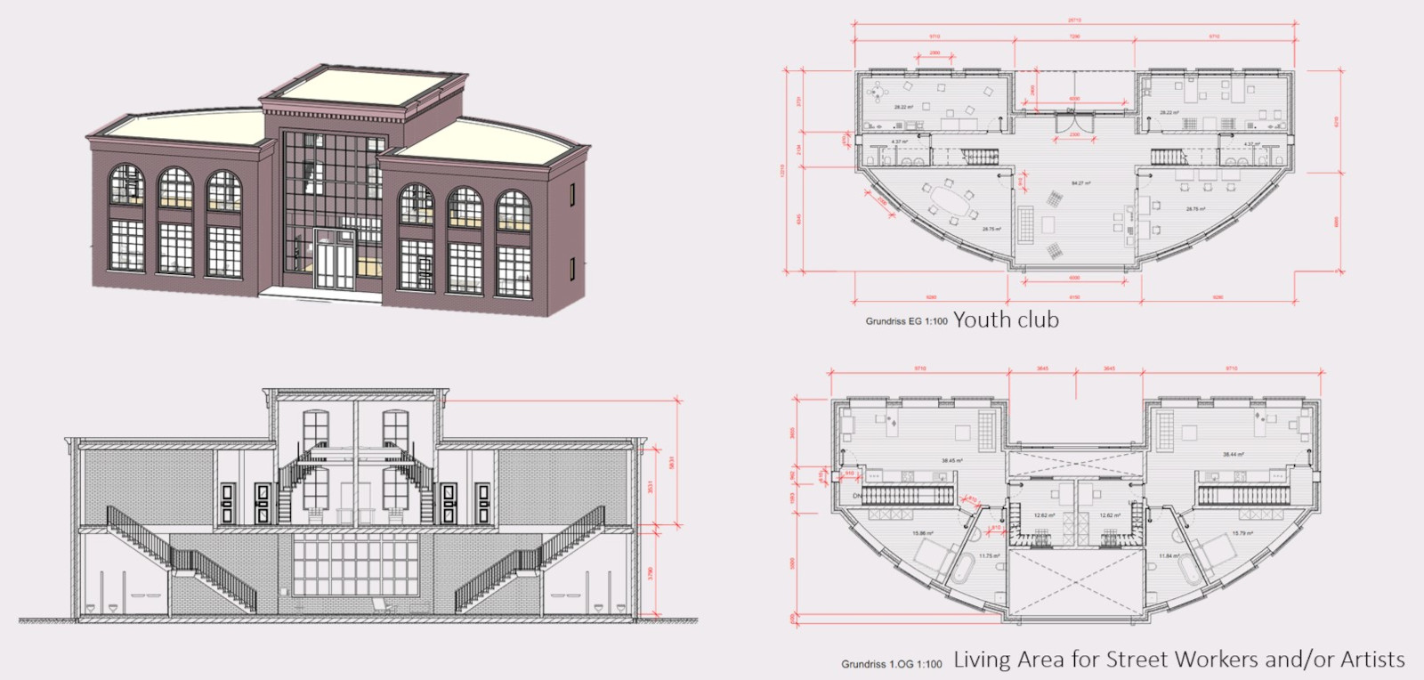
Step 8 comprises the Revit construction of all buildings including floor plans

Of the 2,000 buildings on the Frankfurt Bridges, over 100 were designed as part of the feasibility study. The definition of each building use and construction of the floor plans was to be carried out in detail for all 2000 buildings during the planning phase.  

Stiftung Altes Neuland Frankfurt GNU

The buildings to be constructed in step 8 are designed according to the building register and placed on the bridge surface

This is an iterative process: If it is determined in step 9 (see below) that a building contributes to the shading of residents along the bridge, its height or width is reduced or its position on the bridge surface is changed.  

Stiftung Altes Neuland Frankfurt GNU

In step 9, a neighbourhood analysis is carried out to determine the extent to which residents living near the bridge are shaded by the structure

The compensation model for shading must be designed based on the degree of shading. If the degree of shading is particularly high, bridge buildings may have to be redesigned or reduced in size. In addition, the type and extent of visual protection must be agreed with the residents on a building-by-building basis so that people cannot see into the windows of residents from the bridge. 

As soon as excessive shading is detected, the "glass bridge corpus" alternative must be analysed to determine whether the conversion of solar radiation into heat in summer represents a burden and whether thermochromic glazing is necessary. 

Stiftung Altes Neuland Frankfurt GNU

In the residents' analysis in step 9, all houses along the bridge corpus are recorded and the potential impact on their windows, balconies and front gardens is taken into account in order to draw up the compensation plan on this basis

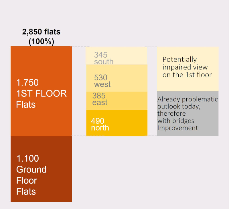
According to the initial results of the feasibility study, the impact on the view from the street-side windows caused by the bridges is rather minor for the majority of the apartments - compared to the status quo. Nevertheless, the compensation plan must be worked out in great detail in the concept planning phase and cover all apartments along the bridge in order to increase the acceptance of the development plans.

Stiftung Altes Neuland Frankfurt GNU

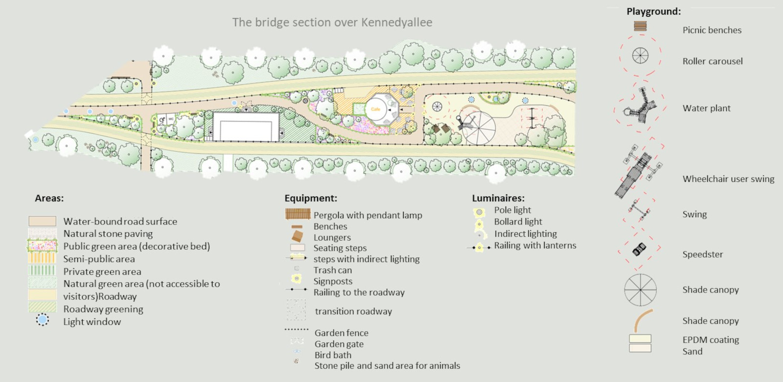
In step 10, all landscaping details per section must be planned: surfaces, equipment and luminaires

The area planning must also include a detailed bed and planting plan  

Stiftung Altes Neuland Frankfurt GNU

Step 10: For safety reasons, the lighting planning must be very detailed for each section - both for the areas on the bridges and for the areas under the bridges

Stiftung Altes Neuland Frankfurt GNU

As with all other planning steps, lighting planning in step 10 must be closely interlinked with other planning groups: For example, good lighting (even insect-friendly amber-coloured) represents increased safety for people, but for wildlife along the bridges (especially in outdoor areas) it can potentially be a nuisance - something to be agreed with environmental planning officers 

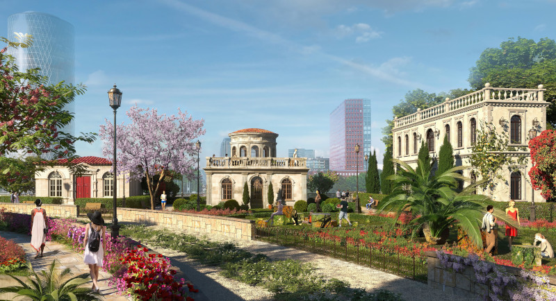
Step 11: Each architectural section of the bridges should be visualised with at least one view to give citizens an idea of each neighbourhood

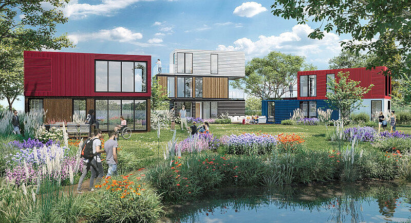
The visualisations are to be seen as a promise of performance that protects citizens from agreeing to an aesthetically positive-looking plan, only to later find a lovelessly designed bridge section á la "motorway bridge with prefabricated buildings on top" in their own section on their doorstep, claiming that they want to build particularly innovatively or cost-effectively.   

The visualisations define the architectural style, the intensity of the greenery and the structure of the building arrangement (density, sequencing, etc.). They also give an impression of how the thematic orientation of a neighbourhood is implemented (see visualisations of "Little Italy" and "Container student flats at IT College" below). 

Stiftung Altes Neuland Frankfurt GNU

Only with these "promises of performance" can one expect citizens to vote in favour of the development plans for the Frankfurt Bridges

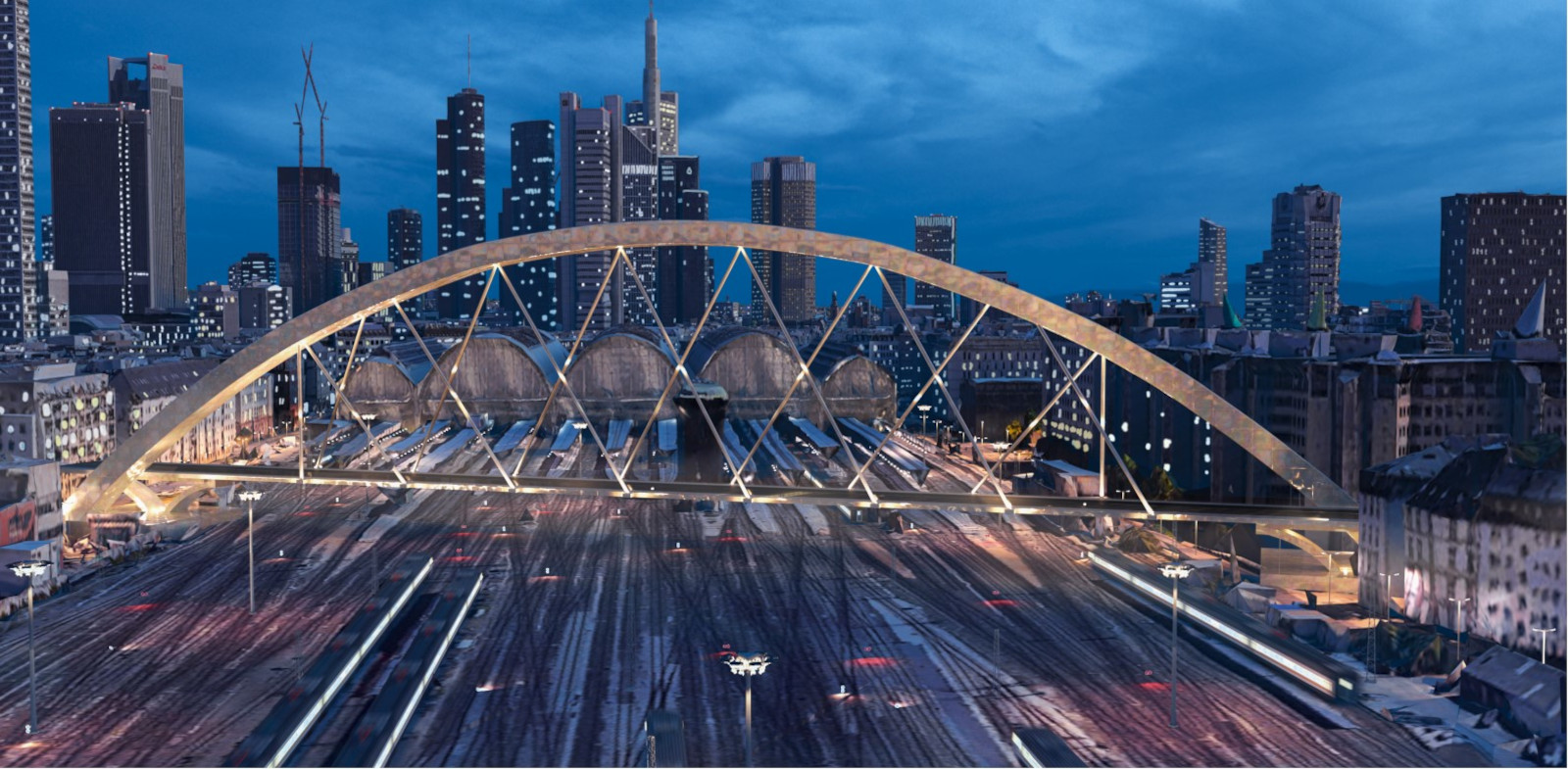
In step 11, the sections that do not run directly past residents but would be a defining feature of the cityscape must also be visualized: the "bridges of Frankfurt bridges"

This applies to the three bridges planned over the Main, as well as to the large bridge over the tracks of Frankfurt Central Station
 

Stiftung Altes Neuland Frankfurt GNU

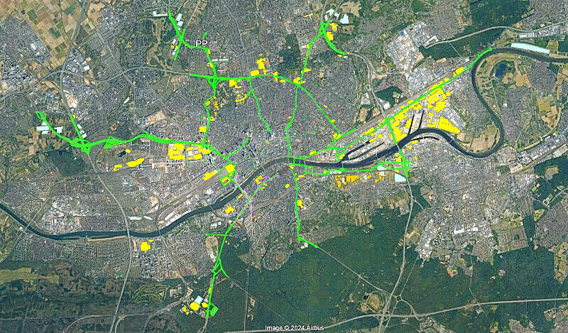
In step 12, all above-ground integrable structures along the bridge that can be used to supply energy and create the water-sensitive city are recorded: primarily building and car park roofs

As part of the feasibility study, all flat building roofs and potentially roofable car parks along the Frankfurt Bridges with a minimum area of more than 500 square metres were recorded. These areas can potentially be used to collect water and solar energy.  

In the concept planning phase, contact must first be made with the property owners and tenants to check which car parks can be covered and which roofs can structurally withstand a load of PV systems.   

A cost-benefit concept must then be drawn up on how the property owners and tenants of the properties in question can be encouraged to co-operate in this expansion of Frankfurt's energy and water infrastructure.  

Google Earth
Google Earth

In step 13, all underground structures along the Frankfurt Bridges are planned: Pipes, cisterns, energy storage tanks, probe fields

Stiftung Altes Neuland Frankfurt GNU

In step 14, a preliminary fire protection concept is drawn up for the entire bridge route

There must be hydrant outlets at regular intervals along the sides of the bridges, from which water can be drawn by the "bridge fire brigade" in the event of a fire to extinguish fires in buildings or elements on or along the bridges. The aim is to improve the fire protection situation of the buildings along the bridges through the construction of the Frankfurt Bridges. The bridges themselves cannot burn - they are designed like streets or green spaces in the city.  

Special fire engines are on standby on the bridges anyway. These aerial rescue vehicles can manage with turntable ladders of around 16 metres, as the Frankfurt Bridges are already 7 metres high, so that it is potentially also possible to rescue buildings that are a maximum of 9 metres away from the edge of the bridge at a legal height of 23 metres. 

Stiftung Altes Neuland Frankfurt GNU

Step 15 involves planning how bridge transport and local public transport in Frankfurt can be optimally harmonised with each other

The centrally controlled autonomous bridge traffic on Frankfurt's bridges has no direct connection to traffic on the ground. The only exceptions are potential direct access routes to hospital emergency rooms for the bridge ambulances.   

Apart from this, however, it is necessary to define where there are stations on the bridges that correlate with the local transport stations on the ground. In addition, two of the three new Main bridges are planned to be two-storey, so that the bridge traffic runs at the top and the lower level is available for cyclists and pedestrians at ground level as a protected road continuation.  

Google Earth

As soon as the eight development plans have been approved, the actual planning can begin

The actual "planning phase according to HOAI" also takes approx. 5 years. It builds on the detailed concept planning for the entire bridge route. The more thoroughly the detailed concept planning of the bridges (body, buildings, surface, area under the bridges, infrastructure of the bridges and their connection to the city's supply system) is worked out in advance, the clearer the objectives for the subsequent actual planning process: This can be based on a detailed master plan.  

Andrey Armyagov-dreamstime.com

The detailed masterplan should be included by the Planning Company Ltd in its statutes under the heading "non-profit purpose" as a target orientation: This will provide the public and developers with a high degree of planning certainty regarding the course, appearance, infrastructure and development of the bridges.  

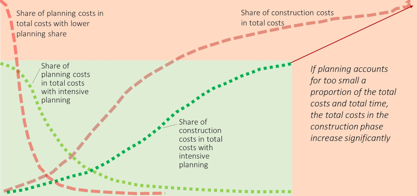
The more thorough the planning is, the quicker and, in particular, the cheaper the construction phase can be

The four- to five-year concept planning phase should only cost 30 to 35 million - but the planning phases in accordance with HOAI should take up at least 20% of the total budget at 5 to 6 billion. Both planning phases cost a fraction of the construction costs, but together take as long as the construction phase 
Stiftung Altes Neuland Frankfurt GNU

The planning of the Frankfurt Bridges must be detailed, descriptive and in a non-profit framework to ensure public acceptance

Even in the concept planning phase before the start of planning in accordance with HOAI, the design of the Frankfurt Bridges must be so clear and so comprehensively coordinated with all stakeholders in a master plan that the required development plans meet with general approval from citizens and authorities.  
Detailed, well-coordinated concept planning also saves a lot of time and money in the subsequent HOAI service phases.  

The non-profit nature of the Concept Company Ltd and the official Planning Company Ltd. also ensures a high degree of acceptance and transparency and thus efficiency and effectiveness for the overall project.