What are you looking for?

Shirin Kriklava - Stiftung Altes Neuland Frankfurt GNU

Effects of the bridges on the city climate

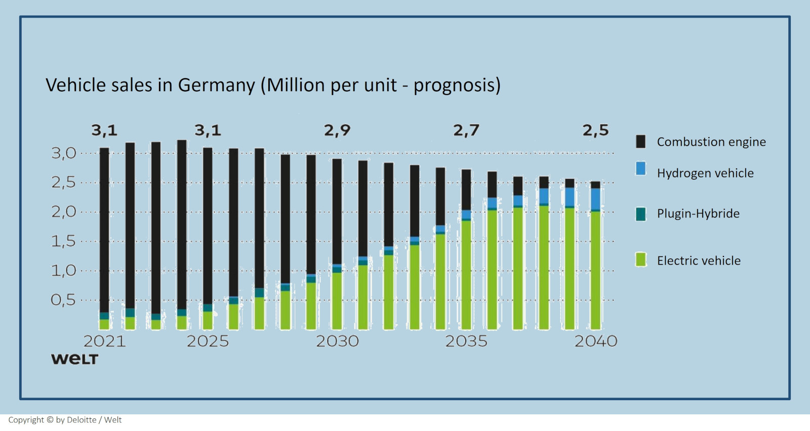
In micro-scale terms, Frankfurt's bridges have a positive effect on the urban climate: The shade cast by the bridge corpus noticeably lowers the perceived temperature in the street space below, making it pleasantly cool there on hot summer days. Bridge buildings and medium-high planting also provide pleasant shade on the bridge corpus. At the same time, due to their columnar character, the Frankfurt bridges represent only a minor obstacle to air flow, thus maintaining the ventilation of the street space. Furthermore, it can be assumed that the bridges will not cause a significant increase in the immission load: The predicted decrease in traffic-related air pollutants by the time the project is completed will benefit the Frankfurt bridges. This is because the number of e-cars and hydrogen trucks will increase significantly in the coming decades and replace the pollutant-emitting combustion engines.

Content: The thermal and dynamic impact of Frankfurt's bridges is analysed exemplarily on a study area in the city centre with the help of computer simulations

The section of Mainzer Landstraße starting from Platz der Republik was chosen as the study area, as this was identified as the potential "worst case passage" of the Frankfurt bridges.


The thermal conditions with regard to temperature and local flow behaviour were analysed as they appear on a hot summer day in the ACTUAL versus PLAN condition. Furthermore, the wind dynamic effects of the Frankfurt bridges were simulated in the same study area, with an average cloudy day as the meteorological starting position, on which a common superordinate wind system comes into play. Several inflow directions were considered.


Potential effects of the bridge construction on pollutant accumulation under the bridges were not analysed, as a significant decrease of pollutants in the road space can be expected anyway until the completion of the bridge construction due to the expected rapid increase of emission-free e-cars and hydrogen trucks.

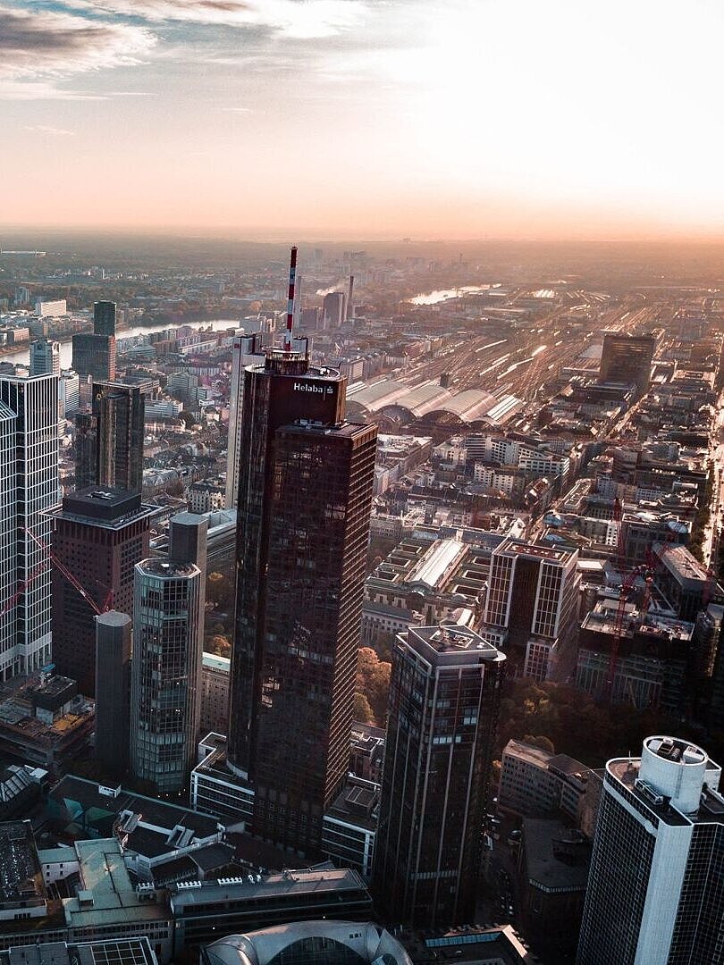
With a total surface area of only two square kilometres, the Frankfurt bridges do not influence the climate of the 250 square kilometre city of Frankfurt on a mesoscale, but only on a microscale

Jan-Philipp Thiele - unsplash.com

Since Frankfurt's bridges only criss-cross the city like a fine network, they have no influence on the city's climate on a large scale.


In certain road sections, however, their impact on the surrounding area can be predicted by simulations.
 

As with any structure, the most relevant thermal factors are shadows cast and the interference with or alteration of wind currents.


In terms of pollutant loading, like any structure, they restrict large-scale air exchange; however, because they provide a second level of traffic that relieves congestion on the streets below them, this must also be considered in the final evaluation.

Stiftung Altes Neuland Frankfurt GNU / Stadt Frankfurt am Main
mpalis - depositphotos.com

The climatic effect of the bridges is however locally quite noticeable, as a view of the surface data shows

Area cityof Frankfurt: 250 km²

•of which fully sealed traffic areas: 52 km2 and

•Vegetation areas: 98 km²


Vegetation areas in thebridgecontext: 1,5 km²

•green area created on the bridges: 1 km²

•additional upgrading of 0.2 km² directly next to the bridge

•Additional unsealed green space: 0.04 km² in the FFM urban area

•additional vitalised green area in the urban area through bridge irrigation: 0.2 km²

•additional trees planted in the inner city area: 1,000 trees

Accordingly, the Frankfurt bridges indirectly do a lot of good for the city climate locally: by reducing road traffic, watering green spaces and trees throughout the inner city area, and as an alternative to the usual sealing of open spaces as a result of the increasing demand for housing

Stiftung Altes Neuland Frankfurt GNU

In order to identify the neuralgic points at which the bridges in Frankfurt pass, the Frankfurt Climate Plan Atlas and the Rhine-Main Air Quality Control Plan were used as a basis

Lucas Lindau - Stiftung Altes Neuland Frankfurt GNU

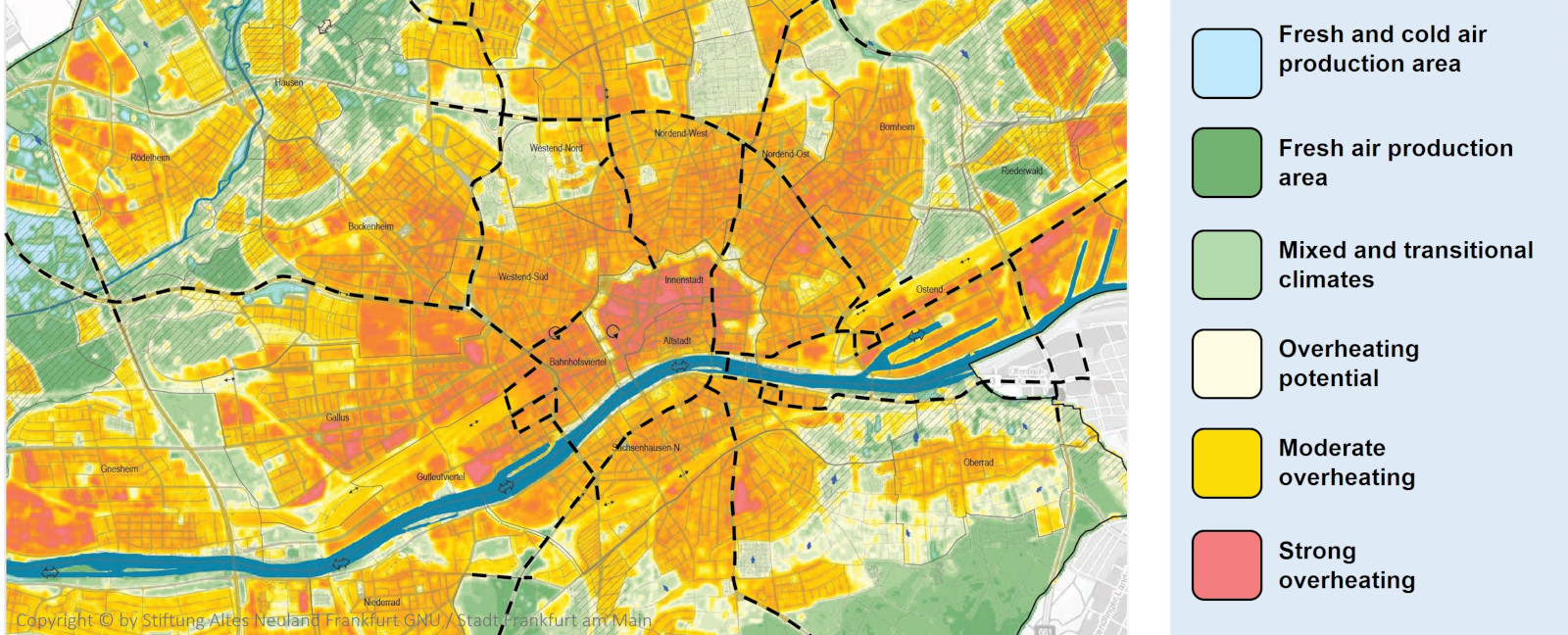
The thermal situation of a city is usually depicted in so-called "climate function maps". For Frankfurt, such a map can be found in the "Klimaplanatlas Frankfurt", which the city had prepared in 2016.


German cities have the immission pollution of the air by nitrogen oxides and particulate matter determined for their region within the framework of the so-called "Clean Air Plan". Frankfurt's situation is currently recorded in the Clean Air Plan Rhine-Main 2020.


Along the course of the bridges, these maps can be used to determine which road sections may tend to aggravate the stress situation and should therefore be the focus of simulations that show or forecast the influence of the bridges on the urban climate; conversely, potential for improvement can also be identified for these sections.


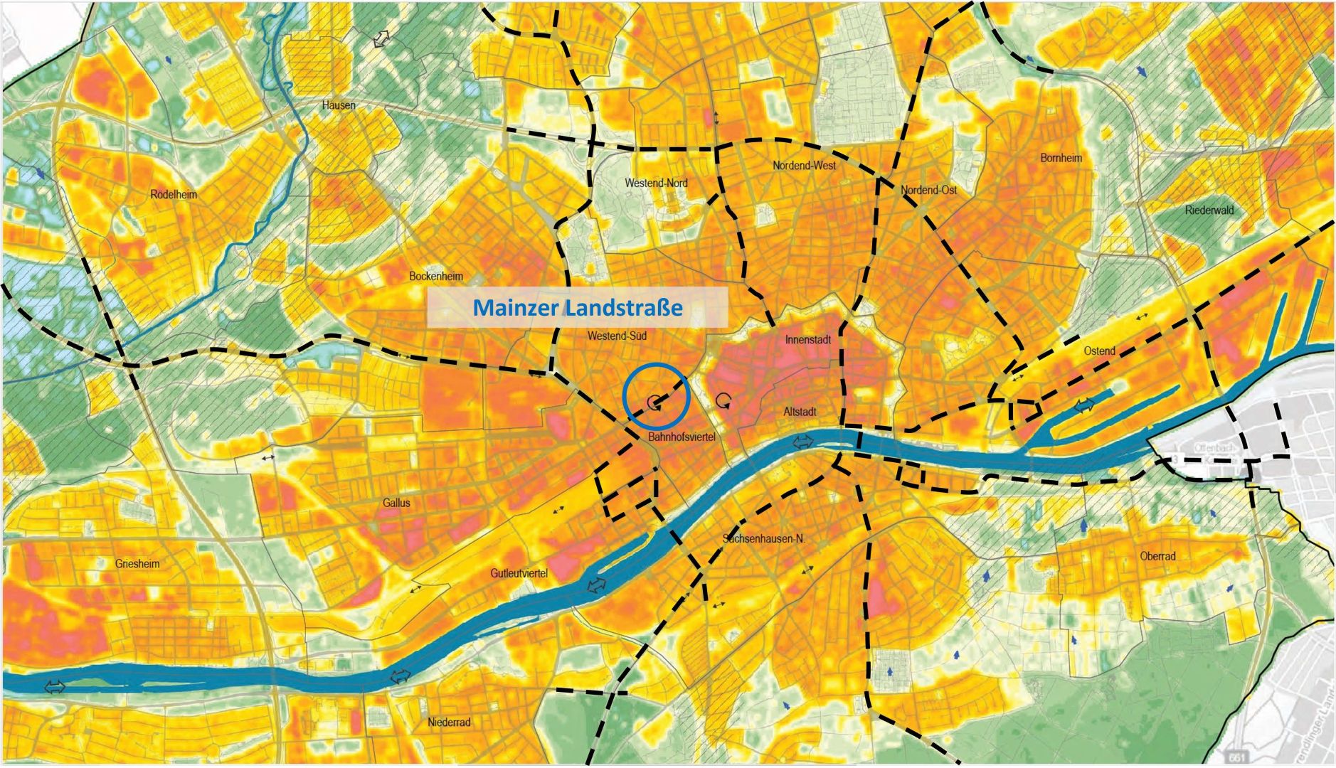
Thermal load and pollutant load are highest in the inner city - (1) Thermal load

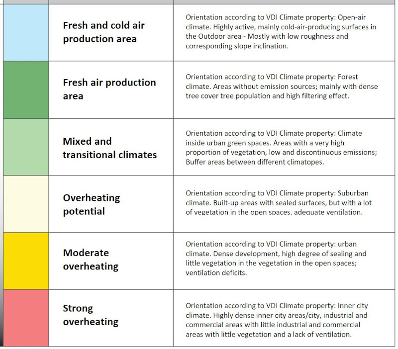
The climate plan atlas shows which urban areas tend to overheat in summer, making it too hot and/or too oppressive for people to live there. Excerpt from the Frankfurt Climate Atlas: The darker the red, the more overheated the area.

Stiftung Altes Neuland Frankfurt GNU / Stadt Frankfurt am Main
Stiftung altes Neuland GNU
https://developer.chrome.com

Thermal load and pollutant load are highest in the inner city - (2) Pollutant load

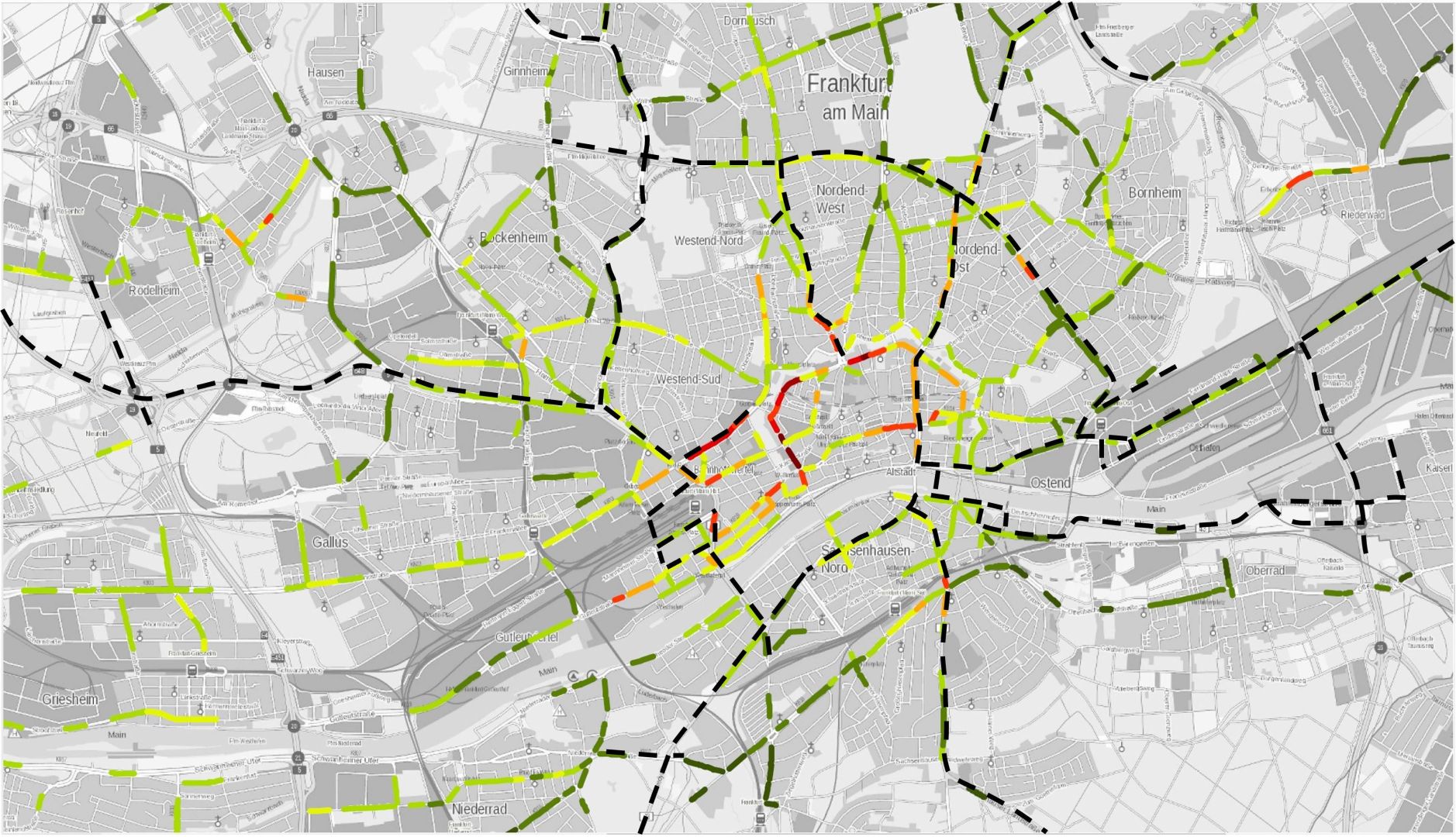
The nitrogen measurement plan along Frankfurt's major traffic axes is a good indicator of the overall traffic-related pollutant load in the respective urban areas.


The map section from the nitrogen oxide analysis of the LRP Frankfurt shows in red areas with the highest pollution.

Stiftung Altes Neuland Frankfurt GNU / Hessisches Ministerium für Umwelt, Klimaschutz, Landwirtschaft und Verbraucherschutz

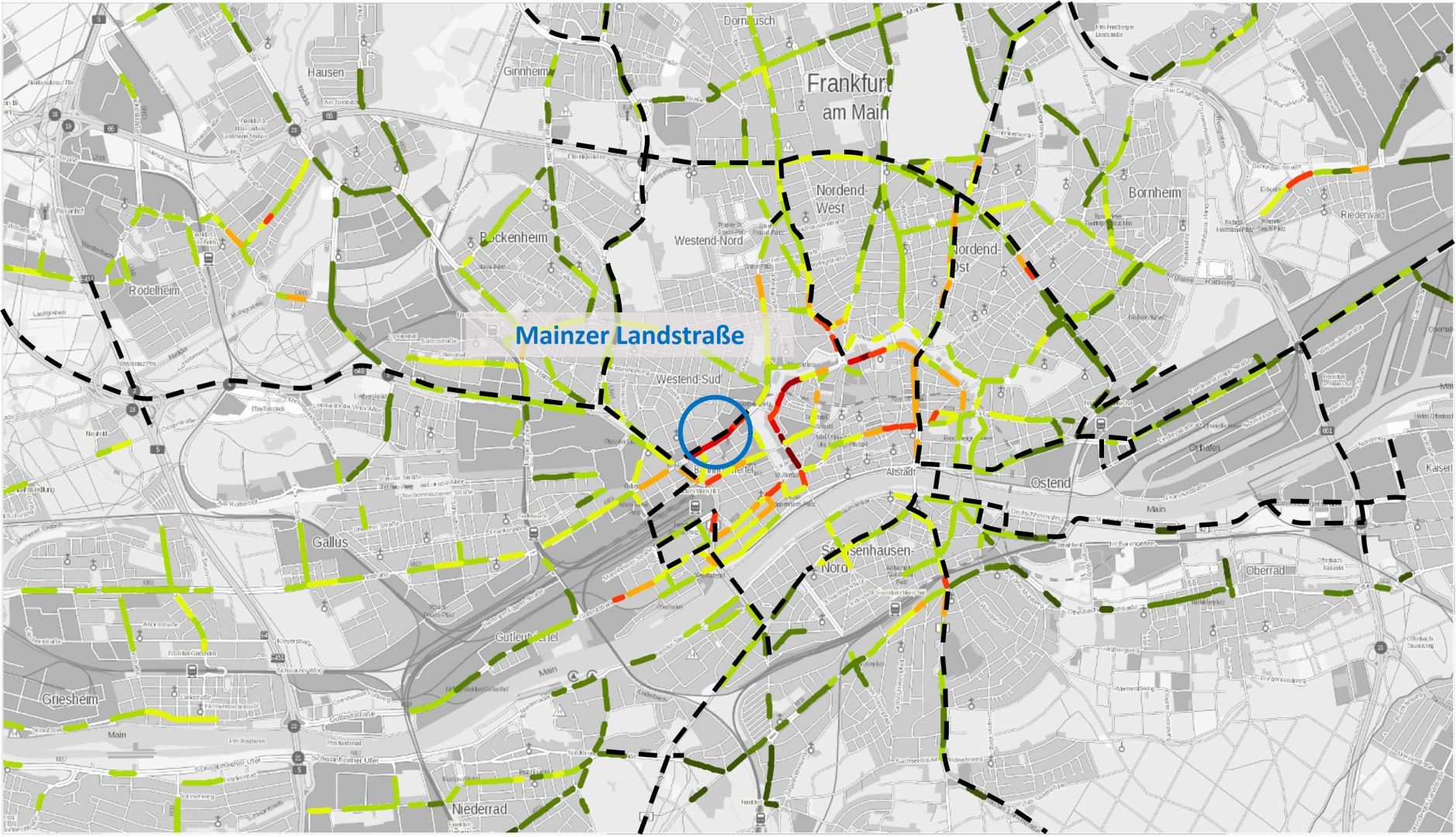
If one compares the neuralgic areas on both plans, there is an exemplary location on Mainzer Landstraße that is critical in both plans

Stiftung Altes Neuland Frankfurt GNU / Stadt Frankfurt am Main
Stiftung Altes Neuland Frankfurt GNU / Hessisches Ministerium für Umwelt, Klimaschutz, Landwirtschaft und Verbraucherschutz

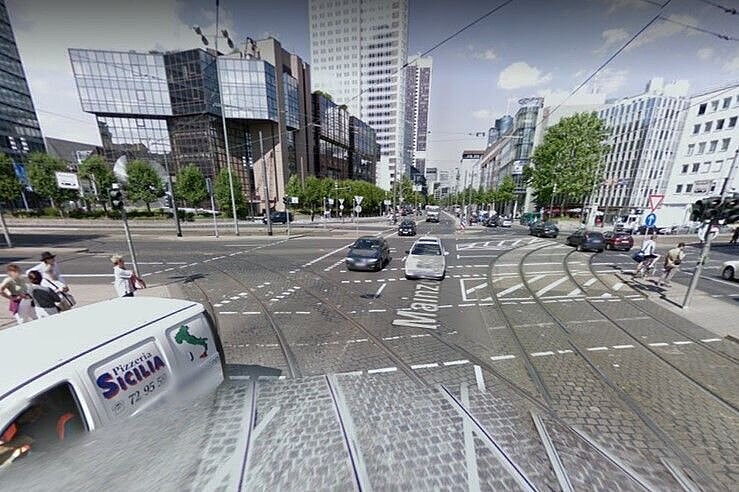
The characteristics of the study area already suggest that it is problematic in terms of urban climate

Characteristicsofthe Mainzer Landstraße

•The Republic Square is a large traffic area.

•the Mainzer Landstrasse leading to it lies partly in a high-rise canyon with.

•Wide street canyon with parking on both sides

•High degree of sealing by asphalt and paving stones, hardly any vegetation and open spaces

•Mainly office buildings

•Closed, very high building complexes

• Four-lane road

•High pollutant and heat emissions due to high traffic volume (39,000 vehicles/24h)

•High NO2 concentration of 46 µg/m³ (forecast from LRP for 2021)

Google Earth
Google Earth

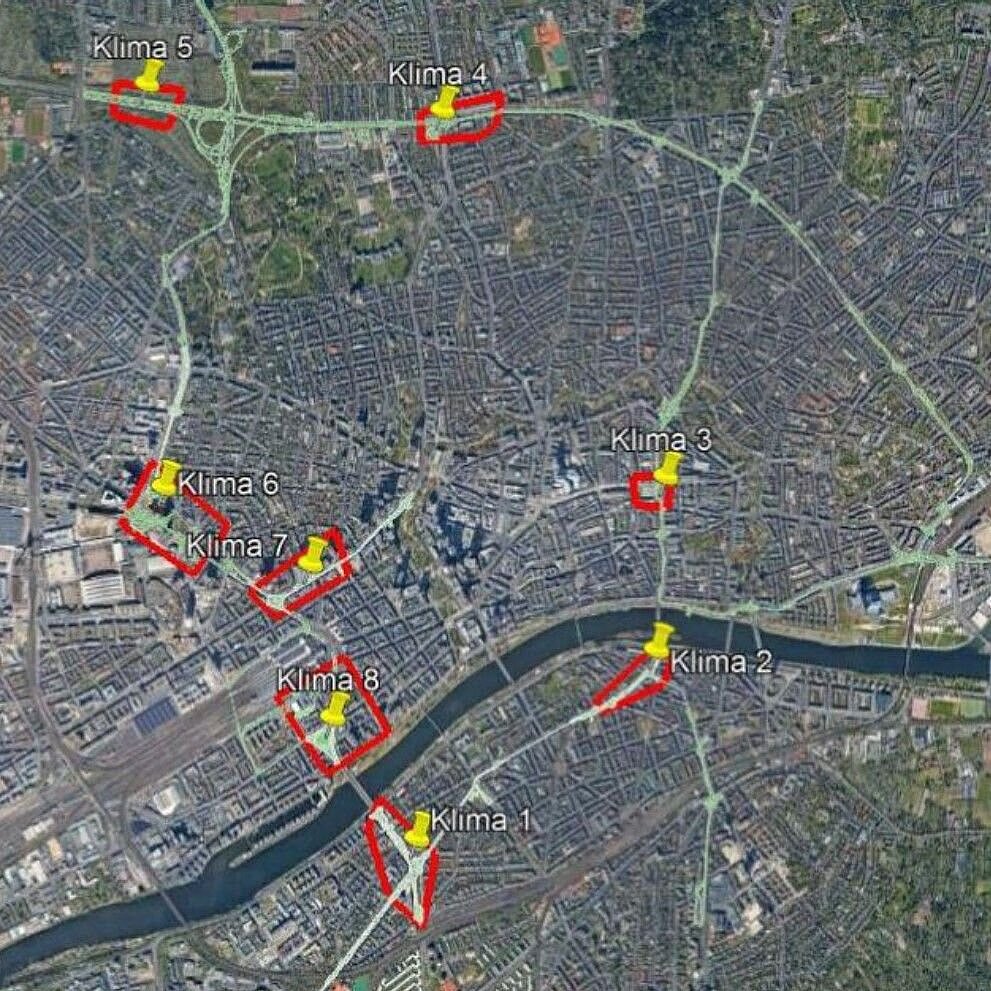
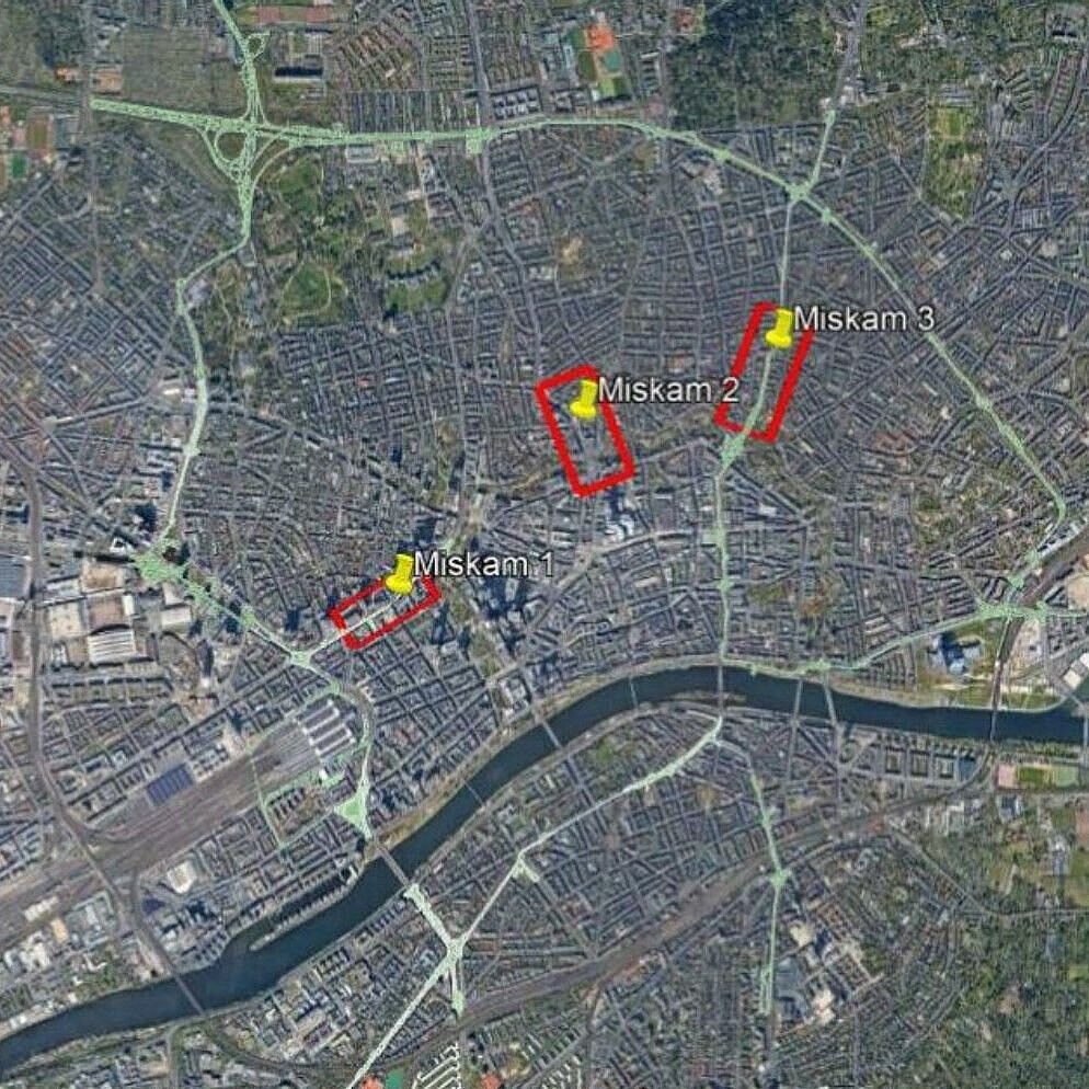
For both an exemplary air hygiene analysis and an exemplary climate analysis, further neuralgic points in Frankfurt have been identified which are already critical along the bridge route.

Ingenieurbüro Matthias Rau / Google Earth

But in order to examine in principle whether the structural concept of the bridges with their dimensions, surfaces, plantings, etc. tends to have a positive or negative effect, the first step was to target the section from Platz der Republik to Mainzer Landstraße as a worst-case example.


At all less critical locations in Frankfurt, the effects are likely to be correspondingly smaller.

.

Content of the urban climatic analysis: How will the thermal and wind dynamic conditions along Mainzer Landstraße towards Platz der Republik change due to the construction of the Frankfurt bridges?

The effect of the bridge body, including the buildings as well as the new greenery (on and next to the bridges) has been investigated with regard to thermal load and wind comfort. The following questions were taken as a basis:


What is the benefit in terms of thermal conditions of a bridge compared to the current situation?


How do the parameters PET (physiologically equivalent temperature) and wind speed change in the street space or in the area of the nearest buildings?


Which fluid dynamic effects and modifications of the wind field are caused by the bridge?


How far does the thermal and wind dynamic influence of the bridge extend laterally into the development?

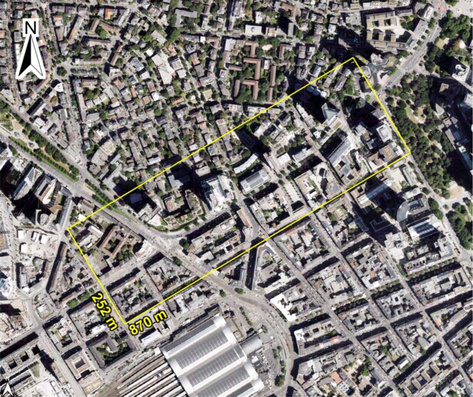
When delineating the study area for the effects of the bridge construction, the adjacent areas must also be taken into account

Stiftung Altes Neuland Frankfurt GNU / Ingenieurbüro Matthias Rau / Google

Due to the spatially limited influence of the Frankfurt bridges, the model area was defined to include the neuralgic section of the Mainzer Landstraße from the Taunusanlage to the Platz der Republik. In addition, the area extends a good 100 metres into the surrounding buildings in order to be able to record all climatic effects of the Frankfurt bridges on their vicinity.

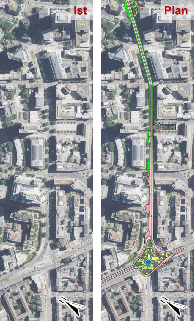
Two simulation runs were made for each of the two model-based analyses

Stiftung Altes Neuland Frankfurt GNU / Ingenieurbüro Matthias Rau / Google

In order to determine the effects of the Frankfurt bridges on the urban climate, two simulation runs each were carried out for both the thermal and the dynamic analysis.


In the first run, the current atmospheric condition along Mainzer Landstraße was simulated without the planned bridge construction (zero case).


In the second model run, the data set was supplemented by the construction of the corresponding bridge section (plan case).

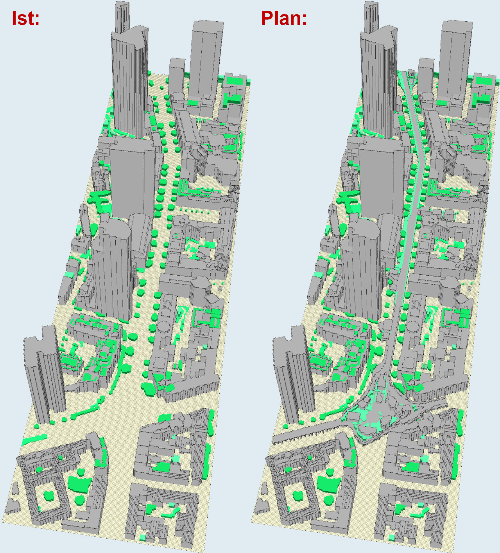
The basis for the simulation was a detailed model of the bridge section and the road with the existing buildings

Stiftung Altes Neuland Frankfurt GNU / Dr. Dütemeyer Umweltmeteorologie

Due to the selected resolution of 1 to 1.5 m, the cubatures of the Frankfurt bridges, the buildings as well as the vegetation can be reproduced very accurately by the model, as can be seen here in the example of the "Envimet" model used.


This high degree of accuracy is of decisive importance for the results, because the better the spatial resolution of the model, the more realistic the results.

Stiftung Altes Neuland Frankfurt GNU / Dr. Dütemeyer Umweltmeteorologie

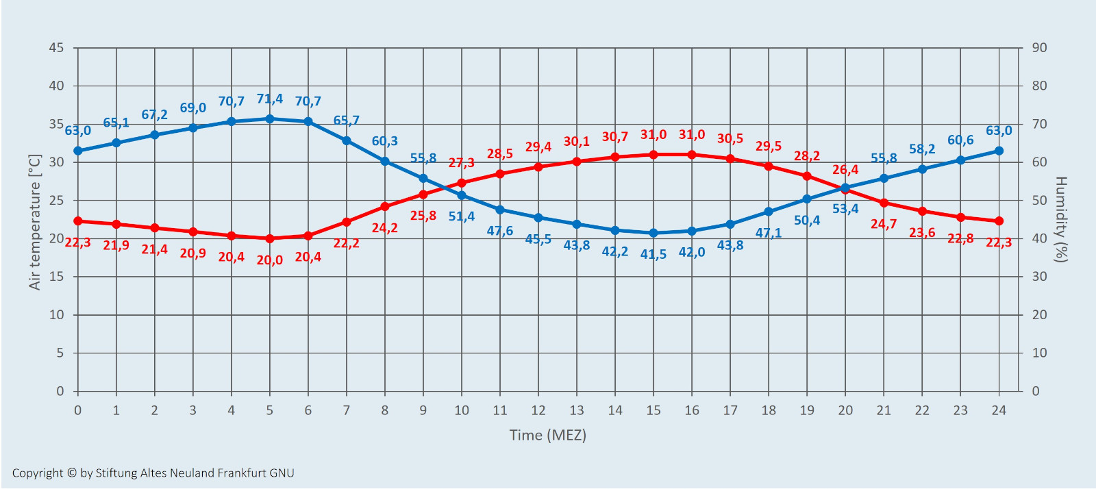
Thermal analysis: The thermal situation was simulated under the meteorological conditions of a hot summer day preceded by a tropical night

In this weather scenario, daytime highs exceed 30° C, while skies are cloudless and overhead winds are light. At night, temperatures do not drop below 20° C.

In temperate latitudes, such hot days are particularly frequent in July and August. Outdoor swimming pools and ice cream parlours are very popular - and shady areas are increasingly sought out.

Stiftung Altes Neuland Frankfurt GNU

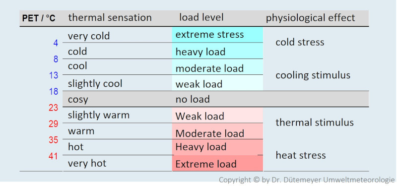
In order to illustrate how people feel thermally under such weather conditions - without or with the Frankfurt bridges - the "physiologically equivalent temperature" (PET) is used

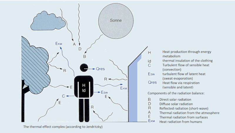
The PET is a measure of thermal comfort that - unlike the measured air temperature, for example - provides information about how comfortable or uncomfortable certain weather conditions feel for the human body.


 Similar to the perceived air temperature, influencing factors such as humidity (sultriness), wind speed (sweat evaporation), heat radiation from the environment (buildings, road surfaces) and solar radiation (albedo effect, sunstroke) are taken into account for this purpose.

Dr. Dütemeyer Umweltmeteorologie

The effects that the Frankfurt bridges have on the characteristics of the PET can be seen in principle from a direct comparison of the model results of the zero and plan cases

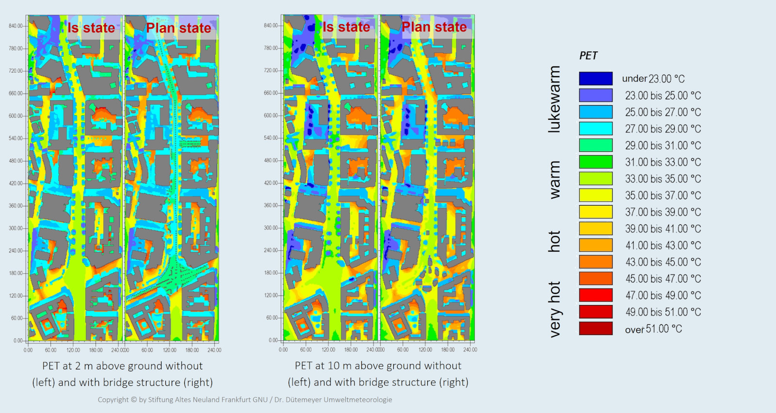
The comparison shows: Without the shady bridge, the PET rises up to 37 degrees on a hot summer day - with the bridge, however, it is only 27 to 29 degrees

The situation is shown at 3 p.m. (summer time), when the highest daytime temperatures prevail and the thermal load tends to be greatest. The height level 2 m above ground describes the conditions in the lower level of Mainzer Landstraße; the level 10 m above ground corresponds to a height of 2 m above the bridge deck.


In the area close to the ground, the temperature deviations can be seen very easily: Without the shady bridge structure, the PET in the Mainzer Landstraße area reaches peak values of 35 or even 37 °C almost everywhere, while the temperatures there are often only between 27 and 29 °C with the bridge corpus in place.


When comparing the PET on the bridge plate, however, the differences are not immediately obvious. This requires a different form of representation...

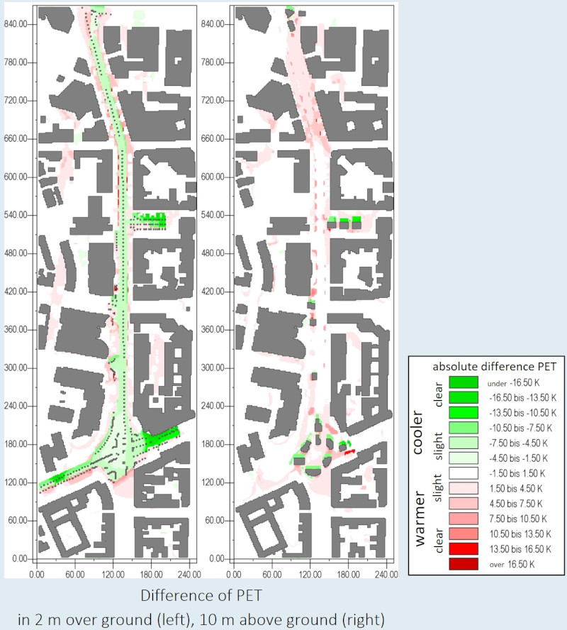
The PET differences between the actual and the planned state can best be shown by means of so-called "difference maps"

Stiftung Altes Neuland Frankfurt GNU / Dr. Dütemeyer Umweltmeteorologie

Since the changes in PET are spatially limited and occur to a rather small extent, especially on the bridge deck, they are best shown with the aid of difference maps in which the differences between the simulation runs of the zero and plan cases are highlighted in colour.


The influence of the Frankfurt bridges on the PET is particularly evident at 2 m above ground, i.e. at the street level of Mainzer Landstraße: The shading of the lower level results in a lowering of the PET by 5 to 7 K. The shading of the lower level results in a lowering of the PET by 5 to 7 K. Since a deviation of more than 6 K in principle results in a new comfort level, the cooling caused by the shadow cast by the bridge structure is of great importance. In the vicinity of the Frankfurt bridges, on the other hand, isolated increases in PET (reddish discoloration) can be detected. However, since the temperature differences are only slightly pronounced, they have no particular relevance for thermal comfort.


At 10 m above ground, i.e. at 2 m above the bridge deck, the superstructures above Republic Square and Francois Mitterand Square result in numerous shadow zones (green). Here, too, the comfort improves by a whole step.

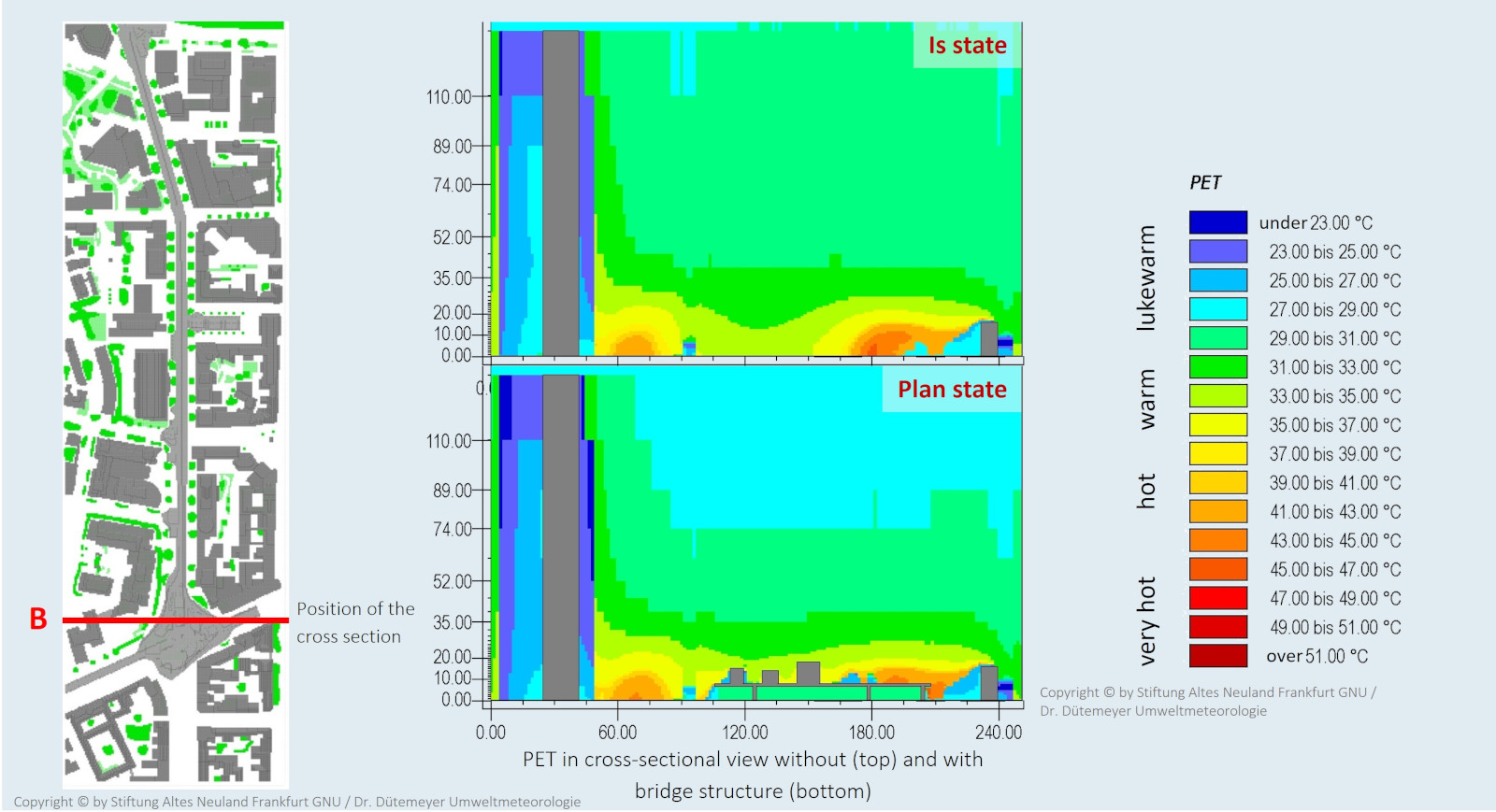
If you look at the PET in the cross-section of Mainzer Landstraße, the lowering of the PET under the bridge caused by shadows becomes visibly apparent. The extent to which it becomes more bearable there in summer is enormous

The Frankfurt bridges cause a slight modification of the thermally induced wind field

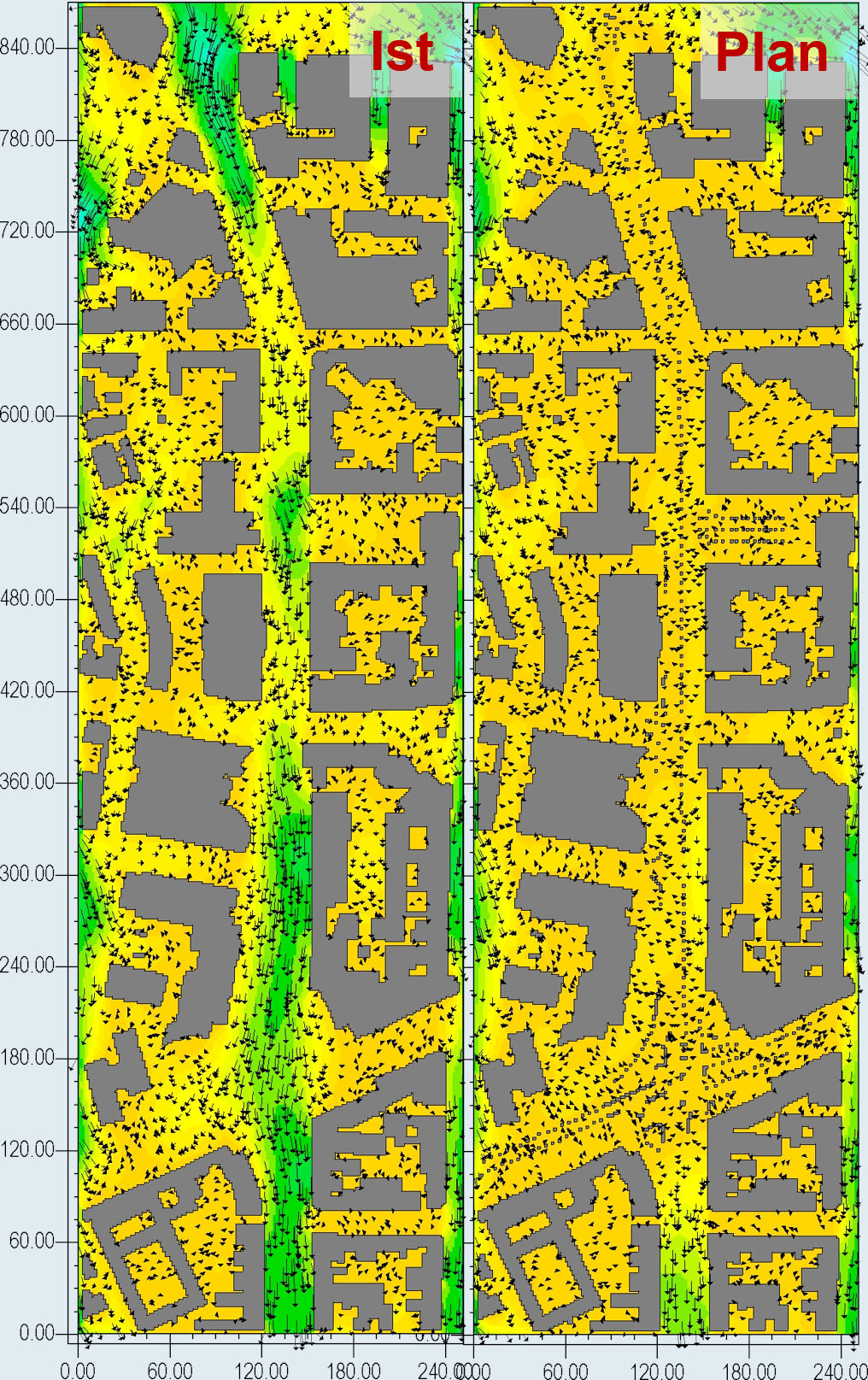
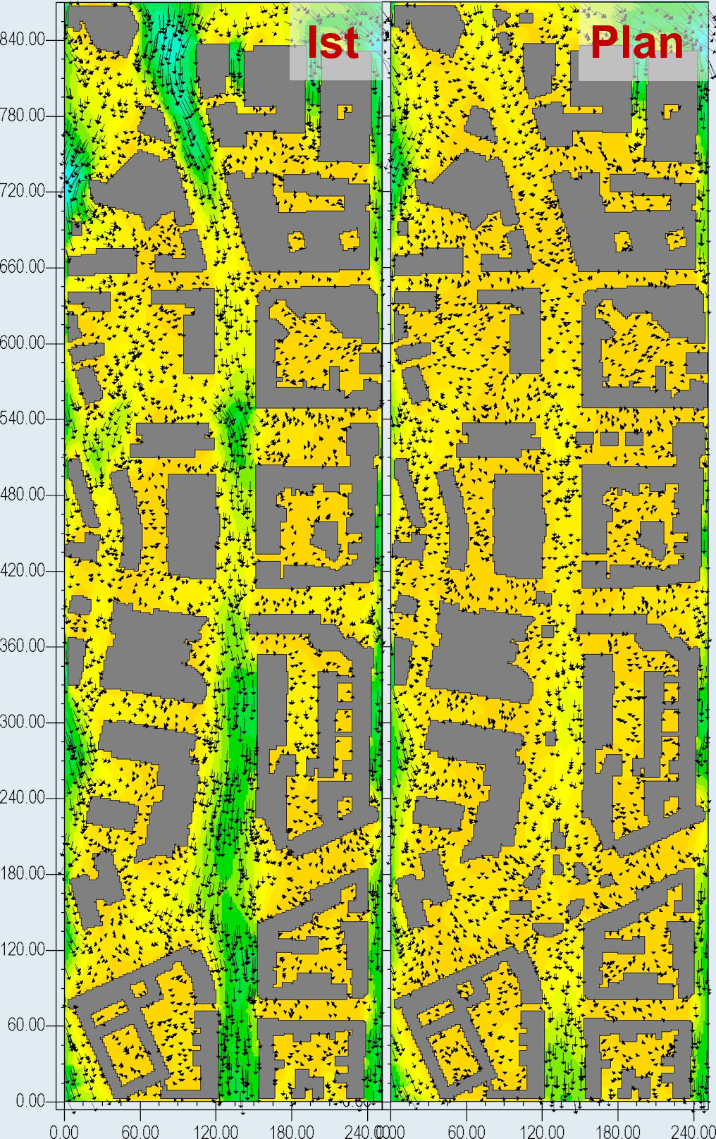
If the superordinate flow field has only low wind speeds, a thermal wind system forms in the city in summer due to temperature contrasts and the resulting pressure differences. Due to the dense building structure of Frankfurt's inner city, however, this is already very weak in the area of Mainzer Landstraße in its current state. At the hottest time of day (3 p.m.), the wind in the street area is rarely stronger than 0.8 m/s at an altitude of 2 or 10 m above ground - a gentle breeze that corresponds to wind force 1 on the 13-step Beaufort scale and is barely perceptible to people. In the inner courtyards of the peripheral buildings as well as in the cross streets leading into the city, there is practically no wind at all.


In the plan condition, the situation does not look fundamentally different both in the lower level and on the Frankfurt bridges. It is true that the wind speeds in the course of Mainzer Landstraße show a tendency towards a reduction in ventilation compared to the actual case - which is not surprising in view of the fact that the Frankfurt bridges and the additional buildings at Platz der Republik act as flow obstacles. However, it is decisive that both the absolute velocities and the reduction amounts (generally less than 0.5 m/s) are on such a low level that in no case a noticeable or physiologically relevant deterioration of the air exchange can be assumed. Of course, this is even more true for the downstream streets in the vicinity of Mainzer Landstraße, where the thermal-dynamic conditions are even less influenced.

Stiftung Altes Neuland Frankfurt GNU / Dr. Dütemeyer Umweltmeteorologie

Windgeschwindigkeit in 2 m ü. Grund im Istzustand (links) und Planfall (rechts)

Stiftung Altes Neuland Frankfurt GNU / Dr. Dütemeyer Umweltmeteorologie

Windgeschwindigkeit in 10 m ü. Grund im Istzustand (links) und Planfall (rechts)

The change in wind speed due to the construction of the bridges is so small in the study area that it is hardly perceptible to humans

Interim conclusion: From a thermal point of view, the Frankfurt bridges represent an enrichment for Frankfurt's urban climate

From a thermal point of view, the Frankfurt bridges do not lead to a significant deterioration of the current situation. On the contrary, the shadows cast by the bridges, their discreet structure and their greenery create a climatic enhancement of Mainzer Landstraße that can be transferred to all other neuralgic stretches of road.


For thermally induced wind systems, the Frankfurt bridges also represent only a minor flow obstacle, so that even in sunny weather no perceptible impairment of air exchange is to be expected.


In hot summers, Frankfurt's bridges thus create pleasantly cool comfort zones in which shading effects both underneath and on top of the bridges effectively counteract the thermal stress on citizens.

Dynamic analysis: The dynamic situation was simulated under the meteorological conditions of a cloudy day with stronger overlying winds

Ingenieurbüro Matthias Rau

For the simulation of the effects that the Frankfurt bridges exert on the flow dynamics, atmospheric boundary conditions were chosen that correspond to those of a normal cloud-covered day with stronger overhead winds, since possible influences of the bridge structure on the ventilation only become apparent under such weather conditions.


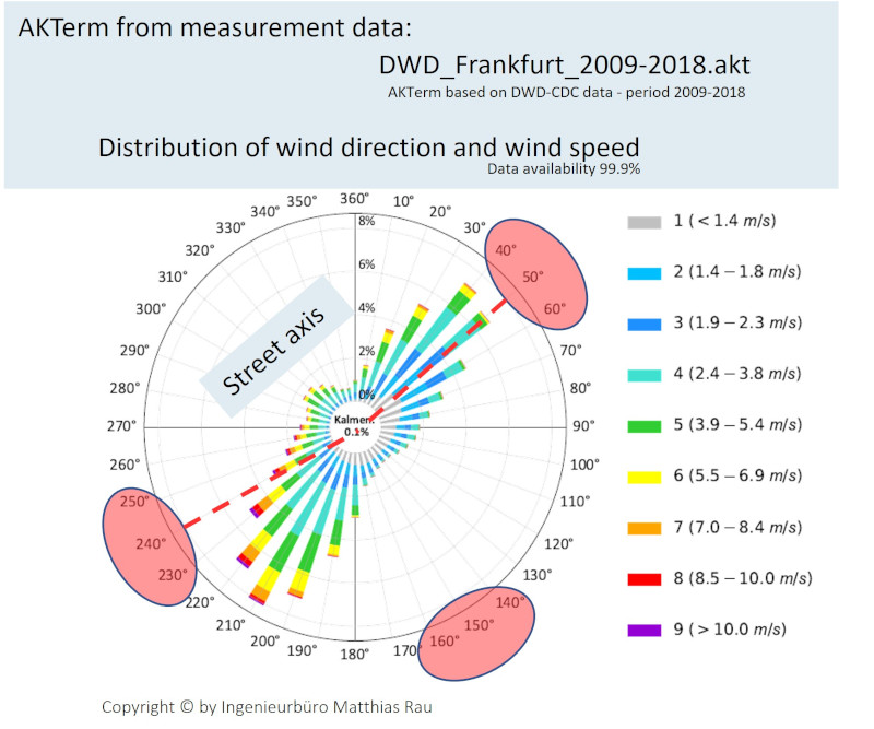
In order to cover the wide range of theoretically occurring flow effects, three different inflow directions were selected, two of which are oriented approximately parallel and one transverse to the axis of Mainzer Landstraße. Thus, the particularly frequent NE and SW winds are also represented (see wind rose). The inflow velocity is based on the long-term average for the respective compass direction.

.

The flow dynamic effects of the Frankfurt bridges vary depending on the wind direction

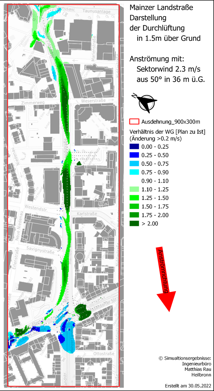
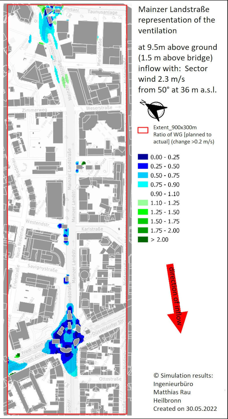
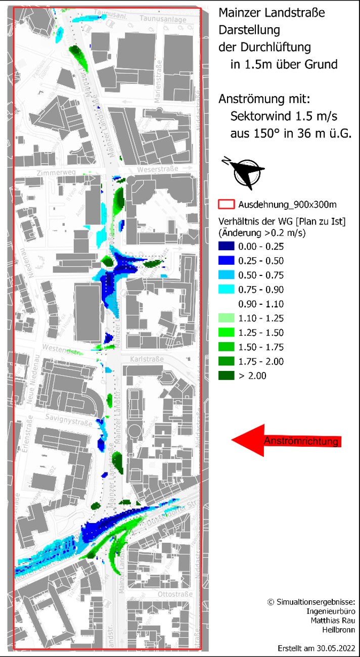
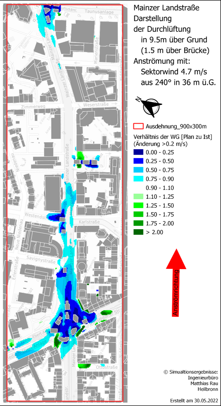
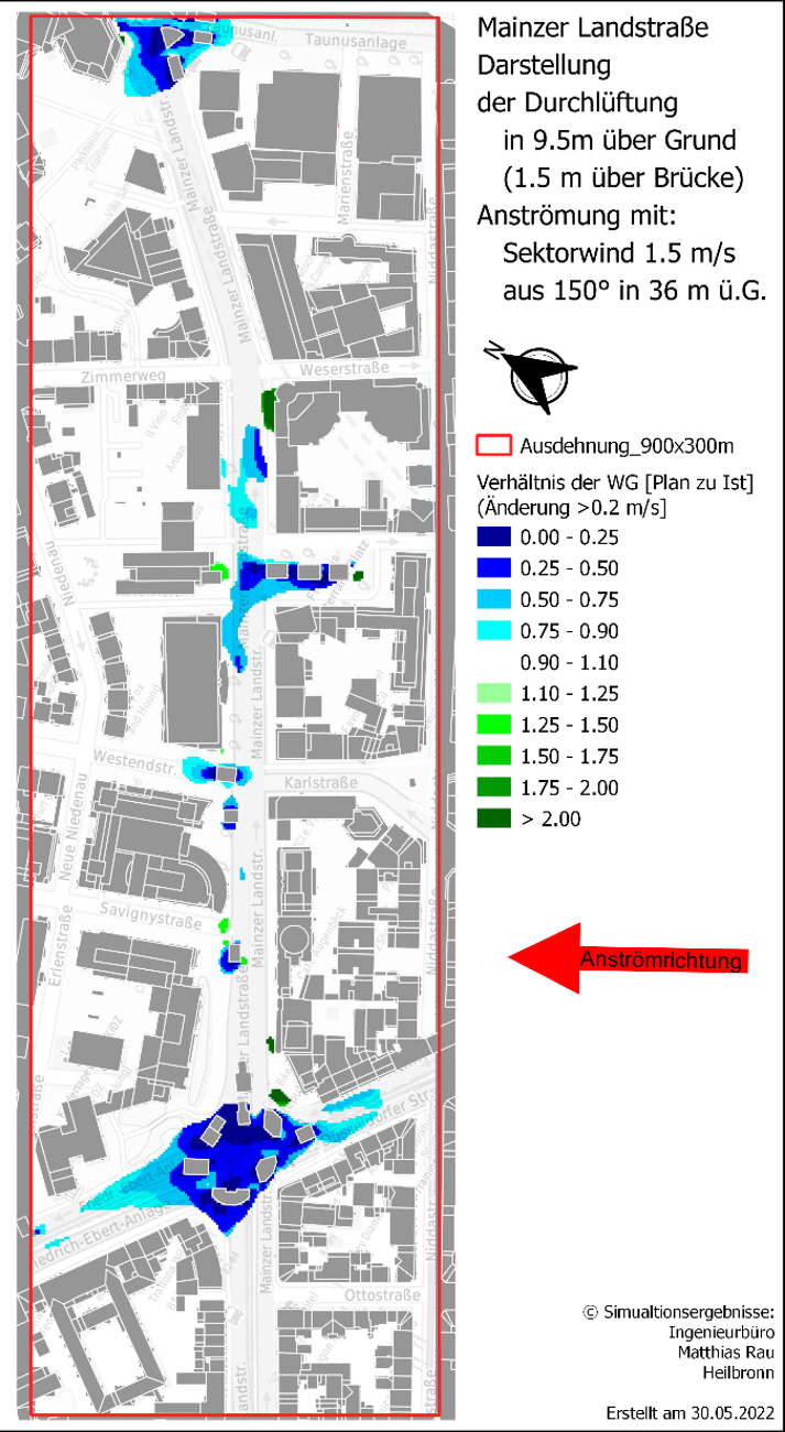
The flow-dynamic influences of the Frankfurt bridges can best be highlighted by setting the simulated wind speeds of the plan case in relation to those of the zero case. A value of 1.5 thus implies an increase in velocity of 50 %, whereas a value of 0.75 implies a decrease of 25 %, with very low changes in wind velocity of less than 0.2 m/s being excluded from the outset.


The presented ratio values are - under the given premise of dynamic wind conditions - not bound to certain wind speeds, but are subject - like the corresponding processes in nature - to the so-called Reynolds independence: If one forms the ratio between two states, then this is dependent on the most different wind speeds.

speed levels can be applied. Only when the overriding wind field is so weak that it can hardly be detected in the road space, the thermal effects gain the upper hand over the flow pattern.


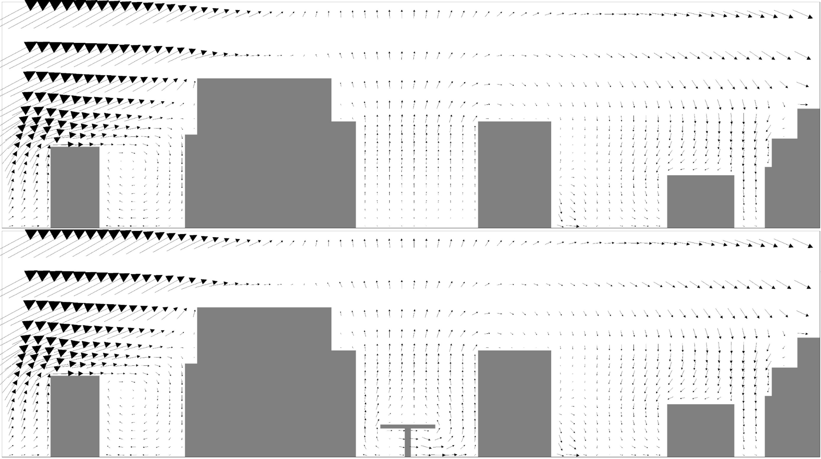
In addition, the simulated flow patterns of the actual and planned case can also be compared in the cross-sectional view. This shows whether and to what extent the occurring turbulences are modified by the Frankfurt bridges. The Mainzer Landstraße southwest of Francois-Mitterand-Platz and the Platz der Republik were selected as cross-sections for this purpose, as these are particularly representative bridge sections.

Modification of the flow dynamics for actual and planned case (I) With northeasterly inflow

Stiftung Altes Neuland Frankfurt GNU / Ingenieurbüro Matthias Rau

With a northeasterly inflow (50°), the wind blows longitudinally through the Mainzer Landstraße. In this case, the Frankfurt bridges channel the air and in places cause an acceleration of the flow in the lower level. This is also known as the Venturi effect. The street space is thus better ventilated. On the bridges, on the other hand, the flow remains largely unchanged; only at the Platz der Republik do the buildings slow down the wind locally.

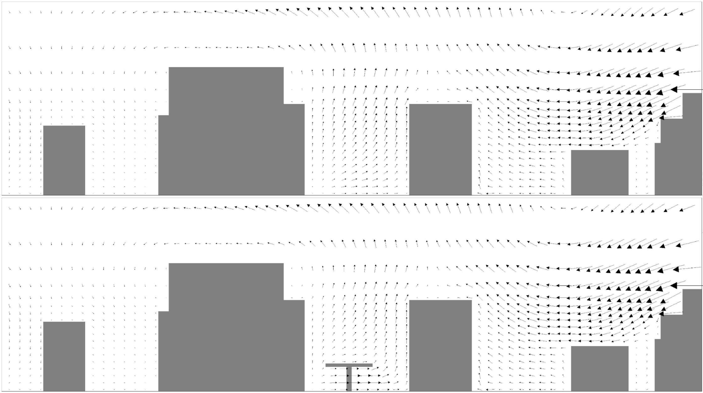
In the vertical cross-sectional view, it becomes clear that the influence on the flow dynamics remains limited to the area of Mainzer Landstraße: In the street northwest of Mainzer Landstraße as well as in the adjacent block development to the southeast, vortex systems are formed in the actual condition, which generate an upward vertical movement in the street canyon of Mainzer Landstraße. This flow pattern is also largely preserved in the plan case with the bridge structure, since the lateral deflection of the wind below the bridge is not propagated into the airspace above.

Mainzer Landstraße - Sectional view of the wind vectors - Here section B: Incoming flow from 50

Top: Zero case without bridge structure - Bottom: Plan case with bridge structure

Stiftung Altes Neuland Frankfurt GNU / Ingenieurbüro Matthias Rau

The cross-sections also reveal that the effects of the bridge construction on the local surroundings are limited: Thus, the flow pattern in the actual state is characterized by a clearly pronounced spiral vortex in the northwestern area of the intersection, which also arises almost unchanged in the plan case. The flow pattern is only modified in the vicinity of the bridge structure with the buildings standing on it, where a rotating vortex is formed due to displacement effects southeast of the building ensemble.

Mainzer Landstraße - Sectional view of the wind vectors - Here section C: Incoming flow from 50

Top: Zero case without bridge structure - Bottom: Plan case with bridge structure

Stiftung Altes Neuland Frankfurt GNU / Ingenieurbüro Matthias Rau

Modification of the flow dynamics for actual and planned case (II) With inflow from the southeast

Stiftung Altes Neuland Frankfurt GNU / Ingenieurbüro Matthias Rau

If the wind blows across the Mainzer Landstraße (150° inflow), the flow pattern changes only very slightly. Isolated lee vortices form on buildings and wake zones under the bridge. There, areas of increased and slowed down flow alternate. Only above the Platz der Republik does the wind field tend to calm down.


This inflow from the southeast is extremely rare for the north-east-south-west oriented section Mainzer Landstraße and thus less relevant; however, since the bridges have a ring or net structure, the wind often hits the bridge structure transversely at other points, which means that the effects simulated here can occur more strongly there.

Within the street canyon of Mainzer Landstraße, the Frankfurt bridges have no influence on the circulation patterns with a given inflow from the southeast, as can be seen from the cross-sectional view: The ideal-typical vortex, which occurs between the towering buildings in the actual state, also occurs without restriction in the plan case. This is due to the column-based elevation of the Frankfurt bridges, which means that the wind is hardly resisted and can flow under the building. Changes in the ventilation conditions are therefore not to be expected.

Mainzer Landstraße - Sectional view of the wind vectors - Here section B: Incoming flow from 50

Top: Zero case without bridge structure - Bottom: Plan case with bridge structure

Stiftung Altes Neuland Frankfurt GNU / Ingenieurbüro Matthias Rau

At Republic Square, on the other hand, a major modification of the wind dynamic conditions takes place with crossflow: While the flow in the actual state advances almost undisturbed into the open crossing area and only changes into a frontal vortex at the northwestern edge due to the impact on a high building complex, the flow field is to a certain extent "disturbed" by the buildings on the bridge in the planned state. Minor turbulence occurs between the buildings and a wake vortex in the lee of the building complex leads to a flow reversal below the bridge level. This can result in reduced aeration in the crossing area.

Mainzer Landstraße - Sectional view of the wind vectors - Here section C: Incoming flow from 50

Top: Zero case without bridge structure - Bottom: Plan case with bridge structure

Stiftung Altes Neuland Frankfurt GNU / Ingenieurbüro Matthias Rau

Modification of the flow dynamics for actual and planned case (II) With inflow from the southwest

Stiftung Altes Neuland Frankfurt GNU / Ingenieurbüro Matthias Rau

In the case of an inflow from the southwest (240°), a complex juxtaposition of areas of increased and reduced wind speed occurs, which ultimately cancel each other out. Analogous to the flow from the northeast, acceleration effects can also occur under the bridge structure, whereas the wind speed on the Frankfurt bridges decreases.


As in the other two cases, however, the effects are concentrated exclusively in the immediate area of Mainzer Landstraße, so that there are no long-distance effects on the neighbouring buildings.

If one compares the vertical sections of the actual state and the planned state with an inflow from the southwest parallel to the road, then differences in the flow pattern are only recognizable for the area of Mainzer Landstraße: Due to the obstacle effect emanating from the bridge structure, lower velocities occur above the bridge in the planned case and higher velocities in the lower area. Below the bridge level, a reduced aeration effect is therefore not to be assumed.

Mainzer Landstraße – Schnittdarstellung der Windvektoren – Hier Schnitt B: Anströmung aus 240°

Oben: Istfall ohne Brückenbauwerk – Unten: Planfall mit Brückenbauwerk

Stiftung Altes Neuland Frankfurt GNU / Ingenieurbüro Matthias Rau

The situation at the Platz der Republik is more complicated: There, the upwind building complex in the northwest leads to the formation of a complex vortex system, which, however, is almost unchanged in the actual and planned state. In both cases, a crossflow is induced towards the southeast, which is in turn locally modified by the bridge structure. It follows that the velocity level below and above the bridge level is locally reduced to a small extent.

Mainzer Landstraße – Schnittdarstellung der Windvektoren – Hier Schnitt C: Anströmung aus 240°

Oben: Istfall ohne Brückenbauwerk – Unten: Planfall mit Brückenbauwerk

Stiftung Altes Neuland Frankfurt GNU / Ingenieurbüro Matthias Rau

Interim conclusion: The Frankfurt bridges can be considered unproblematic for ventilation and the air-hygienic situation

In accordance with expectations, the Frankfurt bridges as flow obstacles lead to local modifications of the wind field, which is pre-dominated by the high buildings on Mainzer Landstraße. Small-scale, highly complex effects occur in the dynamic flow pattern, with zones of reduced and zones of increased wind speed balancing each other out.


Under the Frankfurt bridges, wind acceleration may occur in some places, resulting in better ventilation of the street space. However, there is a tendency for many flow patterns that already occur in the current state of Mainzer Landstraße not to be significantly affected, which is due to the columnar character and associated wind permeability of the Frankfurt bridges.


In any case, the dynamic effects of the bridges are always limited to the immediate vicinity, which is why no far-reaching effects can be assumed.


Since Mainzer Landstrasse is considered a "worst-case" example of the Frankfurt bridges' route due to its exceptionally high and dense perimeter development, all other - less critical - route sections should at best exhibit similar flow patterns and not cause any deterioration in the dynamic effects.


If, contrary to expectations, the urban climatic investigation of other critical points in the bridge route should reveal negative effects in advance, there is also the possibility of providing the bridge corpus with air holes protected by railings in order to improve ventilation.

In addition to the thermal and dynamic analyses under consideration, investigations of the immission load are also common urban climatic pre-planning analyses - which could be omitted here due to the long planning horizon.

The "Frankfurt Bridges" construction project is expected to require a planning phase of 5 years and a construction period of 10 years. In this time horizon, a drastic change in the immission landscape can be expected due to the change in vehicle engines in Germany. Since vehicle emissions, while not 100%, account for a significant portion of the pollutant load on the roads, it is not possible at this point in time to make valid planning analyses for the effects of the Frankfurt bridges in the future on the current data basis.


However, should the introduction of e-cars and hydrogen vehicles proceed at the planned rate, such a significant improvement in the air in our cities can be expected that the bridge structure should have extremely little impact by today's standards in such a "clean" environment.

Immission levels in Hessen have been falling for years - By the time the Frankfurt bridges are completed - in 2037 at the earliest - the situation is likely to ease further

Immission levels from inner-city traffic have fallen continuously in recent decades. In Hesse, for example, as in the rest of Germany, emissions are already below the EU limits. This is due, among other things, to improvements in the emission values of internal combustion engines, which have to meet increasingly stringent requirements. However, a greater reduction can only be expected when internal combustion engines disappear from cities altogether.


Electric cars are being touted as the emission-free alternative of the future, but even they cannot completely escape responsibility for particulate pollution: The reason for this is the general brake abrasion of vehicles - and e-cars are about 300 kg heavier than conventional gasoline engines due to their large batteries, according to studies, so more abrasion is generated by tire rubber and brake pads when braking. However, this problem is being counteracted by increased lightweight construction, recuperation technology and also research into multi-disc brakes, so that by 2035 the trend is again expected to be offset to some extent.

Pollution levels in Frankfurt have also shown a downward trend in recent years

The fact that the EU limit values for the annual mean values of PM10 and PM2.5 have not been exceeded for many years is an indication that Frankfurt's city air has also become increasingly clean in recent years. At the same time, however, the WHO guideline values, which have only been met in isolated cases and will be tightened again in 2020, make it clear that there is still a great need for action to ensure healthy air quality in Frankfurt.

By the time the Frankfurt bridges are completed in 2035 - 2040, the proportion of internal combustion engines will have fallen dramatically as a result of the steady modernization of transport fleets - and with it the pollution levels on the city's roads

For each city, however, it must be examined separately whether the concept of the Frankfurt bridges also produces a positive - or at least neutral - effect on the urban climate there

Many cities suffer from housing shortages, water shortages for their green spaces, and space shortages for their very ambitious renewable energy expansion goals.


The concept of the Frankfurt bridges could help here - but in order to be able to make definitive statements about its urban climatic compatibility, a separate microclimatic simulation of the potential effects caused by the bridge structures is indispensable for every other city.


This is because not only the building structure of a city, but also many other factors such as the regional climate, the location of the city in the relief, etc. are of central importance for the assessment of such an infrastructural construction project.

Conclusion: Thermally, the Frankfurt bridges are likely to be an enrichment for the city climate; in terms of ventilation and air hygiene, they are unproblematic.

From a thermal point of view, the shadows cast by the Frankfurt bridges, their discreet structure and their intesive greenery provide a climatic enhancement of the Mainzer Landstrasse study area.


Under the Frankfurt bridges, wind acceleration can occur in some places, which improves the ventilation of the road space - only in a few places the wind speed is affected to a comparatively small extent. Overall, however, the existing flow patterns in the study area are only slightly modified, as the column structure of the bridges ensures a high wind permeability.


In both cases, the thermal and dynamic effects are always limited to the vicinity of the bridge structure. Since the study area is one of the most critical points in the course of the bridges in terms of urban climate, the analysis and simulation results can be transferred to all other bridge sections.